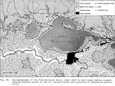
In 1968 Roger Saucier's dissertation on the “Recent Geomorphic History of the Pontchartrain Basin” contained a wealth of information on the early shape of Lake Pontchartrain.
The research paper featured numerous outline diagrams of Lake Pontchartrain over the past several thousand years, how it had changed, plus details on Indian village sites and beach high ground that had been in the middle of the lake at one point in time.
Of particular
interest were the images of Milton's Island Beach Trend, which is now submerged
under Lake Pontchartrain. Saucier reported that a shell dredging barge working
in the area in 1934 pulled up a number of human and animal bones mixed in with its load of sand and shells.
Humans apparently lived on the island hundreds of years ago.
Many maps showing the bottom of Lake Pontchartrain indicate a large shallow sandy area just south of Mandeville. This could be the remnants of the former Milton's Island.
Here are the most interesting diagrams in the document showing Lake Pontchartrain's changes in shape over the eons. Click on the images to make them larger.
That is because at that time New Orleans wasn't there yet, and the big shelf of land that New Orleans would be built upon wasn't there yet either. The land hadn't yet been deposited by the tons of silt and sediment coming down the Mississippi River with each Spring flood. (Area 3 within the red outline). As the silt spread out from the end of the river, it curved around and closed in the east end of Lake Pontchartrain, which was, in the beginning, a large bay on the north shore of the Gulf of Mexico.


