Showing posts with label Maps. Show all posts

Wednesday, April 8, 2026

Early Land Grant Map, Covington to Bogalusa

 Here are several early land grant maps stitched together showing the names of large tract property owners all the way from just south of Covington northward to Waldheim, Bush, Bogalusa on up to the Mississippi state line. 

The red line marks what was known as "The Covington Road"(also called The River Road in some locations). The series of squares indicates the route taken by General Andrew Jackson in 1814 from the John Ford home in Sandy Hook, Mississippi, through Enon and Covington on his way to Madisonville to cross the lake and take part in the Battle of New Orleans. 


Top Half of Map: From Sandy Hook to Bogalusa

Click here to view a close up view of the above map. 

Bottom Half of Map: From Sun to Covington

Click here to see a close up version of the above map.

The maps came from the U.S. Bureau of Land Management

Links of Related Interest:

Jackson Historical Marker Unveiled


Wednesday, July 27, 2022

Columbia Street Poster Map

 Columbia Street in Covington is one of the finest small town main streets in the country. 

It has pretty much everything: a variety of good restaurants, hardware stores, dozens of attorneys' offices, land surveyors, real estate offices, appraisers, art galleries, art studios, a medical spa, three banks (one on the south end and two on the north end), and the main city cemetery. 

Because of its historic significance and current day activities, I have drawn a poster map that labels many of its present businesses and also lists some of its previous business locations. Here is the map:


Click on the above image to make it larger.
To see a close up image, CLICK HERE.

Columbia Street Overview

Also on Columbia Street are the St. Tammany Parish Justice Center, city police headquarters, the Farmers Market, the Masonic Lodge, the St. Tammany Art Association and the historic Columbia Landing, which doubles as a concert stage and picnic area. At the top of the landing is a historical marker and an old-fashioned gazebo where musical jam sessions are often held. 

Over the years its businesses have provided lumber for building homes, fashion clothing for dressing the family, shoes, hunting and fishing supplies, guitars, feed and seed and plants as well as health food items.

In one block there is a nationally-recognized glass design and fabrication firm on one end and a nationally-renowned general merchandise store that's been in business for 146 years on the other end.


Mayor Mark Johnson of Covington accepting a large-sized copy of the map.
August 5, 2022

Several motion pictures have been filmed on the street over the years, and a number of commercials have also been made on Columbia Street. It is a favorite location for block parties, auto shows, and parades all year long: Mardi Gras parades, the fair parade, the St. Patrick's Day parade. 

The knife and archery shop is a landmark business, as is the coffee shop.

It's a street like none other, a major corridor for trade from Mississippi in the early years, and currently a favorite shopping destination for locals and visitors alike. 

Tammany Trace, one of the nation's top recreational cycling trails, crosses it, as did the railroad track a century ago when passenger trains would bring hundreds of visitors to the community every summer weekend.

Columbia Street has long been one of Covington's most important thoroughfares, made possible by the business owners who located there and by the customers who shop there.


Columbia Street in the early 1900's


Paul Swain's back and forth video showing images on Columbia Street
1990 then 2020


See also:

Columbia Street Scene

Spring For Art 2019

Windows To The Past


Wednesday, June 8, 2022

An Early Tammany Trace Map

 This cartoon map was produced in the early 1990's, the best I can figure, based on the locations noted for the St. Tammany Parish Courthouse, the St. Tammany West Chamber of Commerce and the St. Tammany Tourist Commission. 


Sunday, May 22, 2022

The Houltonville Map

 An informative "lesson plan" on Fairview Riverside State Park and the Otis House in particular was prepared some time ago by Ann Durel, interpretive ranger at the park. It included a number of topics, photographs and maps. Here is one of the most interesting. 

During the 1980's archaeologist Allen Saltus studied part of the Tchefuncte River and Lake Pontchartrain and found abundant evidence of historic structures and submerged vessels. This Madisonville area map shows the location of Jay's Sawmill, White City, Ferry Landing, the Fairview House (Otis House), and the railroad tracks coming in from the north. 


Click on the image to make it larger.

This map was part of Saltus' "Submerged Cultural Resources Investigation of a Portion of the Tchefuncta River" report. 


In 1991 Saltus presented the results of his research to the historical society.


Sunday, May 1, 2022

All Roads Led To Madisonville

 This 1863 map shows St. Tammany Parish and neighboring areas with key connecting roads. Click on the image to make it larger. 


Commentary: 

In the top left is Holmesville, Mississippi, a key community at the time and a hub of political influence. The railroad passed it by however, and it barely exists today. The road east to Columbia, Ms, is shown, but Tylertown hadn't made it on the scene yet. 

The road between Holmesville down to Covington was a major trade route, supplying Covington with key produce and foodstuffs.  On some early maps of Covington, Columbia Street is actually labelled as "Holmesville Road" in the area of the parish fairgrounds. A 1927 map of the area showed La. Hwy. 25 in front of St. Gertrude's Convent as The Holmesville Road. The goods from Mississippi were shipped by schooner and steamer from Covington and Madisonville down the Bogue Falaya and Tchefuncte Rivers across Lake Pontchartrain to New Orleans. 

Turnpike Road heading northwest out of Madisonville was a well-travelled route at the time, and a road west towards Baton Rouge (now La. 22) was part of the early Spanish "King's Highway." The road heading east out of Madisonville only went to Lewisburg and Mandeville. From Covington the main road going eastward through Hickory across the Pearl River to Gainesville, Mississippi, seemed to be a major corridor. Abita Springs at the time wasn't big enough to be on the map. 

From Gainesville the road continued on to Shieldsboro, which is today called Bay St. Louis. From Shieldsboro two roads headed southwestward, one going to Pearlington and the other hugging the coast and going across Pearl River Island just east of the Rigolets. That southern route would later become the route of the railroad tracks. The highway between Pearlington and the Rigolets would not be built until the late 1920's.

Of some interest is the road coming from Columbia, MS. (top, center), down to Fordeville, where Ford's Fort (The Ford Home) is located. It is now Sandy Hook, Ms.  In 1814, this location played a part in Andrew Jackson's travels from Tennessee to New Orleans to take part in (and win) the Battle of New Orleans. 

Although this map was made 50 years after he passed through, it may show the general track of the route he took southward, passing just west of Bogalusa, across the Bogue Chitto River at Isabel and into St. Tammany Parish, down Old Military Road (La. Hwy. 1082), then along Military Road (La. Hwy. 21) into Covington. Research is now being done to pinpoint Jackson's route because of its historic significance.

From Covington he went to Madisonville and took a boat across Lake Pontchartrain where he joined a large group of volunteers and engaged the British in the The Battle of New Orleans at Chalmette Battlefield, now a national historical park. 

The Darby Map

An earlier map, the Darby Map of 1816, is more concurrent with Jackson's trip. Here it is. 


Click on the map to make it larger

The pink fringed areas are Mississippi, and at this time St. Tammany extended all the way from Lake Pontchartrain northward to Mississippi. Washington Parish had not yet been created. The initials "C.H." in the middle of the map stand for courthouse and indicates where the parish courthouse was when it was located near Enon. This map was made only three years after Covington was founded, and the new town wasn't yet big enough to put on the map. Jack Terry sent me this map following up on our discussions on the 1814 Jackson trip. 

Vivian Davis Borneman of Lacombe wrote extensively on the early roads in Louisiana, and her information on roads which were in use in 1816 is  an important resource for historians. 

She quotes William Darby, who made a survey of roads in Louisiana in 1816, about the possible route of the well-used "Post Road," which was extended in 1803 (the year of the Louisiana Purchase) from the Natchez Trace to Madisonville, Louisiana.

Here is an excerpt of her report:

"The Road from Washington, D.C., to New Orleans- A Post Road from Washington, D.C. to Nashville, TN, had existed prior to 1801. It was extended to Natchez (MS) in 1801 and was called The Natchez Trace.

"When we bought Louisiana from France in 1803, and Governor Claiborne took over in Louisiana, he somehow induced the Spaniards to let him extend this post road from Natchez, through their Spanish West Florida territory to New Orleans..."

She explained that General Wilkinson's road (as it was known in 1823) went from Pearl River westward across St. Tammany and St. Helena Parishes (Tangipahoa Parish didn't exist as of yet), and then onward to Baton Rouge. 

Another major road (the possible Post Road) ran from Natchez down to St. Francisville, then headed southeastward on a diagonal path past the top of Lake Maurepas and headed across the Tangipahoa River straight into Madisonville. "Here, a person took a packet across Lake Pontchartrain and into New Orleans," she stated.

"At Madisonville, a road leads almost directly north, past Horton's Mill, on straight northward to the St. Tammany Courthouse (at that time owned by Robert Lobdell), and then headed northeast to Pearl River. (The Pearl River was used a great deal for traffic.) This road (in Madisonville) was on the east side of the Tchifonta River." 

Her conclusion was as follows:

"The Road from Washington, D.C., to Madisonville, as shown herein, was complete and in use in 1816... Mr. Darby's survey in 1816 does not show General Jackson's Road into Madisonville (known to be in use in 1823). In 1806 Judge Toulmin, at Fort Stoddert, AL, put a Post Road through to Madisonville. 


Fort Stoddert was about 30 miles due north of Mobile, AL

"From Pearl River, the route established by him in 1806 is identical with General Jackson's Road into Madisonville (as shown on an 1823 Bulletin). This was the post road into Madisonville, from Ft. Stoddert in 1806, and it was in use in 1827." 

She also mentioned that Darby's 1816 map, while it does show a few short roads around Baton Rouge, it also shows the one going (all the way) into Madisonville, where a ferry would be taken over the lake into New Orleans.

See also:

Monday, April 4, 2022

Mandeville Business Map 1986

 Thirty-six years ago, in 1986, I drew a pictorial map of Mandeville that showed many of the businesses located there. Here it is. Click on the images to make them larger. 


The overall map


Here are some close up sections of it


The businesses shown are the ones who agreed to pay to be on the map to help with printing costs. 


Cartoon Map Presentation

Saturday, April 2, 2022

Before Tangipahoa Parish Existed

 Tangipahoa Parish was created by Louisiana Act 85 on March 6, 1869, taking land from the parishes surrounding it, namely, St. Helena, Livingston, Washington and St. Tammany. Here is a map from 1853 showing what the Florida Parishes looked like before Tangipahoa Parish was created. 

 
Click on the image to make it larger. 

Everything east of the Tangipaphoa River was in St. Tammany and Washington Parishes, and everything west of the Tangipahoa River was in Livingston and St. Helena Parishes. 

This was exactly 50 years after Washington Parish was created in 1819, taking its territory from the northern half of St. Tammany Parish ( which before that time went to the Mississippi state line to the north.) That action reduced St. Tammany to about half its original size.


Why was Tangipahoa Parish created? Here's an account by one resident who had heard it had something to do with railroad workers liking to drink whiskey.


In 1975 there was again talk about splitting St. Tammany Parish apart, this time east and west, to allow Slidell to have it own courthouse. 

From the Times Picayune from 47 years ago...

 
--------------------------------------------

See also:

Courthouse History


Sunday, March 20, 2022

ChefSoiree Map 2022

 Here's a copy of the ChefSoiree map for 2022. The event took place in downtown Covington at Bogue Falaya Park. 

 
Click on the image to make it larger.


Saturday, February 5, 2022

Garlandville Lots 1920's

 Back in the 1920's Garlandville subdivision northeast of Claiborne Hill was selling fifty by 300 foot lots for $100 each. 


Saturday, January 22, 2022

South Abita Springs Promoted

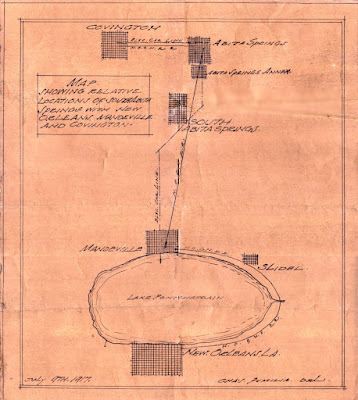
 In 1917 real estate sales in the new southern section of Abita Springs began picking up. Here is a map that showed New Orleans residents where south Abita Springs was located, in relation to Mandeville, Slidell, and Covington. There were two train tracks that served the community. One track was the main railroad from Slidell, and the other was the motor car trolley from Covington to a boat dock on the Mandeville lakefront. 

Click on the image to make it larger and more readable. 

 
A 1917 showing the location of south Abita Springs


There were no bridges across the Rigolets at this time, and Slidell was a small but growing city with several large industries, having been chartered in 1888. 

See also:

Brief History of Abita Springs 

Abita Springs Music History 

Abita Springs Development Proposal 1887  

The Doodlebug Trolley Motor Car 


Thursday, January 20, 2022

The Trolley Motor Car Route

 In 1909 the trolley car that ran between the Mandeville lakefront and downtown Covington opened up for business. The trolley would roll out onto a pier that jutted out into Lake Pontchartrain, steamboats carrying passengers from New Orleans would dock, and passengers would board the trolley right at the end of the pier, then be carried back onto land and onwards to Abita Springs and Covington.

The name of the company operating the trolley was originally the St. Tammany Railway. It was later lengthened to the St. Tammany and New Orleans Railway and Ferry Co., as boats were added. 

It was a great system, and hundreds of visitors would utilize the trolley car to finish their trip to the Abita Springs and Covington hotels of their choice. 

Here is the original printed map of the trolley motor car route. There were actually two rail lines going from Mandeville to Covington. The trolley car route was different than the railroad track route, and they crossed over each other just west of Abita Springs. The train tracks went straight down to Mandeville from Abita Springs, swung by the Mandeville depot, then headed for Slidell.

 
The printed version of the trolley motor car route. 
Click on the images to make them larger.
 
 
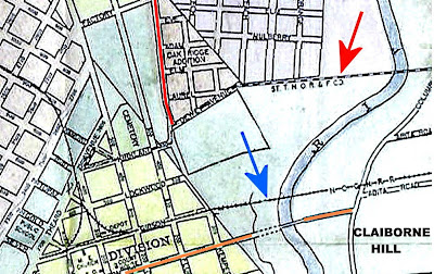
In this 1909 map, the trolley line is pointed out with a red arrow. It crosses the river upstream of Claiborne Hill, enters Covington along East Clark Street, and then goes along Dewey Avenue to Kirkland, past the cemetery and ends near where the police station is today. The blue arrow points to the railroad track bridge over the river, which is today Tammany Trace. 
 
 
In this 1965 aerial photo of Covington, the path of the trolley line is clearly visible through the trees. Collins Blvd. didn't exist during the time of the trolley, so the trolley line route left Covington along East Clark Street, crossed the Bogue Falaya River and headed east towards La. 21 (Military Road). It crossed La. 21 just a little north of  Melissa Lane. 

 
In this recent aerial photo a powerline right of way shows up as a horizontal shadow extending from Collins Blvd., across the Bogue Falaya River and over to Military Road into the Garland Addition. This was likely the path of the trolley line, since in its last few years it was an electric trolley. 


Since the trolley line track bridge over the Bogue Falaya river was further upstream than the railroad track, the two tracks had to cross over each other just west of Abita Springs. Old aerial photographs, the above being from 1965, still showed the path of the trolley car line as it intersected with the railroad line just south of where the Abita Brewing Co. is today.


The trolley car route was still visible as a path through the trees as late as 1978.

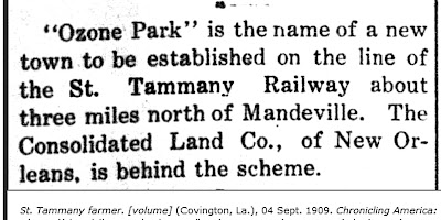
On its way down to Mandeville, the trolley route passed through Abita Springs and headed southward, but veered to the west between North and Soell Streets on a diagonal route to head for Helenberg subdivision and Ozone Park. Once it left there, it headed south but as it pulled into Mandeville it zigzagged back and forth from block to block until it got to the lakefront and pulled out onto the pier. 


The Farmer welcomes the railway and trolley

The Original Source Map

In a stack of old documents recently found in Covington, researchers discovered the original hand-drawn map from which the above printed map was made. Here is a copy of the original trolley "motor car" route map. Some areas are shaded red, yellow or brown to indicate large property holdings along the way.


 Here are four sections of the above map enlarged for detail.

 
Covington, Abita Springs and Alexiusville

 
Helenberg and Ozone Park
The trolley route is a marked by  triple parallel lines from the top right


Chinchuba and Glendale Heights

 
Mandeville and Bayou Castin


The trolley line ends on the pier into the lake, while the train track heads southeast into Lacombe and Slidell.  


Depots
 
 
On the trolley car line, there were depots at Helenberg & Ozone Park.
Helenberg was a subdivision developed by the owner of the trolley line
 
Spellings Differ  
 
The owner's name was "Joseph Birg," and on some maps the name of the subdivision is spelled "Helenbirg" while on other documents it is spelled "Helenberg" with an "e."
 

 Ozone Park was developed as a new town next to the trolley line.
 
 
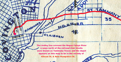
In Covington, the trolley depot appeared to be near the intersection of Kirkland and North New Hampshire St.  It entered into Covington along East Clark Street, merged with what is now North Claiborne, and then merged into Kirkland Street.

The trolley car at the Abita Springs depot


The trolley ended up bankrupt in 1918. Efforts to save it, and even extend a separate line of Madisonville, did not succeed.


Steamer Margaret To Connect With Trolley
 
 
Motor Car Trolley Changes Schedule

To purchase a booklet with the complete story of the Mandeville to Covington Trolley Car, click on the link below:


See also:

The Doodlebug Trolley Motor Car 

Helenbirg Subdivision