
Introduction
The mission of the U.S. Geological Survey (USGS) is to provide the hydrologic information and understanding needed for the best management of the Nation's water resources. As a part of this effort, the USGS has been involved in monitoring the water quality of surface- and groundwater resources of the Lake Pontchartrain watershed in southeastern Louisiana (fig. 1) since 1927.
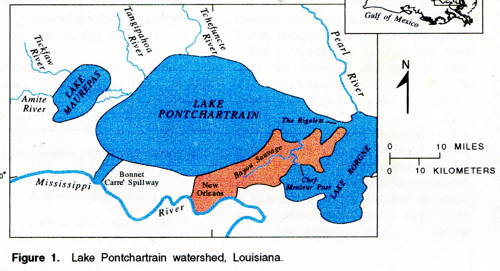
The exact origin of the lake is unknown, but it probably was formed along with Lake Borgne as a series of estuarine lakes several thousand years ago, when Bayou Sauvage was the main channel of the Mississippi River.
As the course of the Mississippi River shifted, Lake Pontchartrain eventually became isolated from the river. However, the lake still received periodic inflow from the river. Unusually large spring floods occasionally broke through the river's natural levees and flowed into the lake. A break in the natural levee was known locally as a crevasse.
The present-day Bonnet Carre Spillway is located at the site of a crevasse that last opened in 1874 and remained open for 10 years. Lake Pontchartrain (fig. 1) retains a connection to the Gulf of Mexico through two tidal passes, the Rigolets and Chef Menteur Pass, and, therefore, is more accurately described as an estuarine embayment than a lake.
The lake covers almost 635 square miles but is shallow (fig. 2), ranging from 6 to 16 feet deep with an average depth of 11 feet.

Wind is the major factor that controls circulation patterns in the lake, although small tidal changes also affect currents in the lake. A wide range of land uses, commercial fisheries, and other recreational uses place varied demands on the lake.
The New Orleans, Louisiana, metropolitan area increased its urban acreage by 67 percent from 1956 to 1988. The area along the northern shore of the lake also is rapidly increasing in population. Commercial fishing remains an important contributor to the local economy, with revenues estimated at $35 million annually. Fish and shellfish harvested for both commercial and recreational purposes include blue crab, brown shrimp, white shrimp, red drum (redfish), spotted seatrout (speckled trout), catfish, and menhaden.
The Bonnet Carr6 Spillway, located in the southwestern part of the lake, is a major component of a series of flood-control structures constructed after the disastrous Mississippi River flood of 1927. The structure, completed in 1932. consists of 350 concrete bays, each equipped with removable timber beams.
The structure can divert as much as 250,000 ft3/s (cubic feet per second) of Mississippi River water into the lake to lower flood stages in the river in the New Orleans area. The structure has been opened seven times for flood control purposes, most recently in 1983.
Water Quality of the Watershed
One of the primary characteristics of an estuary is the tidal exchange of saltwater and freshwater. However, the tidal range in the lake is very low, only about 1/4 foot. Therefore, the flushing action of the tides is slow, estimated to be 90 to 120 days for water entering the western part of the lake to exit through the Rigolets.
Salinities of the lake range from fresh (less than 0.5 parts per thousand salt) in late winter to brackish (about 10 parts per thousand) in late summer. Salinities also vary from east to west and from the surface to the bottom and are affected by complex interactions between weather and tides.
Historically, seasonal salinity changes were gradual, allowing the lake to be inhabited by a wide range of estuarine organisms. Estuarine organisms typically require different salinities at different stages in their life cycles, and they have adapted to enter and exit the lake at different times of the year.
There are now (1995) indications that human-induced alterations in tributary flows, dredging, and canal construction have altered this gradual cycle, making salinity changes more abrupt. Many organisms, especially juvenile fish and larval shellfish, are not well-adapted to abrupt change.
In addition to tidal exchange, five major tributaries contribute water to Lake Pontchartrain: the Pearl, Tchefuncte, Tangipahoa, Tickfaw, and Amite Rivers. The Pearl River flows into the Rigolets and Lake Borgne, freshening the eastern part of Lake Pontchartrain, especially in the spring. The annual mean discharge for the Pearl River near Bogalusa, Louisiana, is 10,070 cubic feet per second.
The amount of Pearl River water entering the lake is controlled by interactions between the river stage and tidal action. The Tchefuncte and Tangipahoa Rivers flow directly into Lake Pontchartrain. The Tchefuncte River has an annual mean discharge of 163 cubic feet per second, and the Tangipahoa River has an annual mean discharge of 1,176 cubic feet per second.
In addition to the freshwater and nutrients needed by the lake's ecosystem, these rivers also add fertilizers, pesticides, and fecal-coliform bacteria from agricultural and residential areas; dairy farm waste; and urban storm water runoff.
The Tickfaw and Amite Rivers also contribute freshwater and non-point pollutants to the lake through Lake Maurepas. The Tickfaw River has an annual mean discharge of 387 cubic feet per second, and the Amite River has an annual mean discharge of 2,117 cubic feet per second.
Monitoring Programs
Water quality in Lake Pontchartrain is monitored by the Louisiana Department of Environmental Quality and the USGS. More than 100 sites have been established to determine and evaluate the quality of the lake, about 10 of which are currently (1995) in operation.
The sites also are utilized for problem-oriented research in hydraulics, hydrology, and related fields to understand the lake processes sufficiently well to predict their response to stress, either natural or human-induced. Water-quality constituents monitored in Lake Pontchartrain include: nutrients such as nitrogen and phosphorus; inorganic chemicals such as chloride, sodium, and calcium; trace elements such as lead, cadmium, and mercury; phytoplankton; and pesticides and other synthetic organic compounds.
The USGS, in cooperation with the U.S. Army Corps of Engineers, has maintained six monitoring sites on the Mississippi River between St. Francisville and Venice, Louisiana, since 1973. Four sites are currently in operation. Long-term data from these sites will be useful in evaluating the effects of freshwater diversions of river water into Lake Pontchartrain and Louisiana's coastal marshes.
Issues
• Eutrophication, The processes by which nutrients are added and consumed in the lake ecosystem are known as eutrophication. If more nutrients are added to a lake than the lake can assimilate, this enrichment can contribute to the growth of noxious algal blooms, depletion of dissolved oxygen, and fish kills. The addition of excessive nutrients from sources such as non-point runoff from the northern and southern shores may increase the potential for algal blooms and degrade the water quality for commercial fisheries and recreational uses.
• Freshwater diversions. A site near the Bonnet Carre Spillway has been proposed for the construction of a controlled freshwater diversion of Mississippi River water to enhance oyster production in Mississippi Sound, add sediments to benefit swamps and marshes, and reduce
the adverse effects of saltwater intrusion in the lake. Concerns have been expressed by user groups that the additional river water would promote algal blooms and reduce harvests by fisheries.
• Toxic contamination. In general, there is no indication of toxic substances in Lake Pontchartrain exceeding U.S. Environmental Protection Agency alert limits. However, improper boat maintenance; automobile exhaust; stormwater runoff from highways; and improper disposal of motor/engine oil, household cleansers, and lawn maintenance products all can introduce toxic elements, excessive fertilizers, and pesticides into a lake with a limited capacity to assimilate or remove them.
Sustained monitoring and quality-control measures are necessary, because the cumulative effect of these point and non-point source contaminants would substantially reduce the ability of this urban estuary to support a diverse plant and animal community.
Communication and Coordination
Communication and coordination among the scientists in the USGS and members of the public and private sectors are critical components of the USGS mission. Interagency cooperation has proved highly effective and consists of coordinated activities by Federal, State, and local agencies; universities; and the private sector that have water-resources responsibilities or interests.
Specific activities of these working groups include:
• Exchange of information on and prioritization of water-quality issues of regional and local interest.
• Identification of sources of water-quality data and other information.
• Assistance in design and scope of project elements.
• Review of project planning activities, findings, and interpretations, including reports.
This report was issued in April of 1995 by Dennis K. DemcheckU.S. Department of the Interior U.S. Geological Survey Fact Sheet FS-118-95