
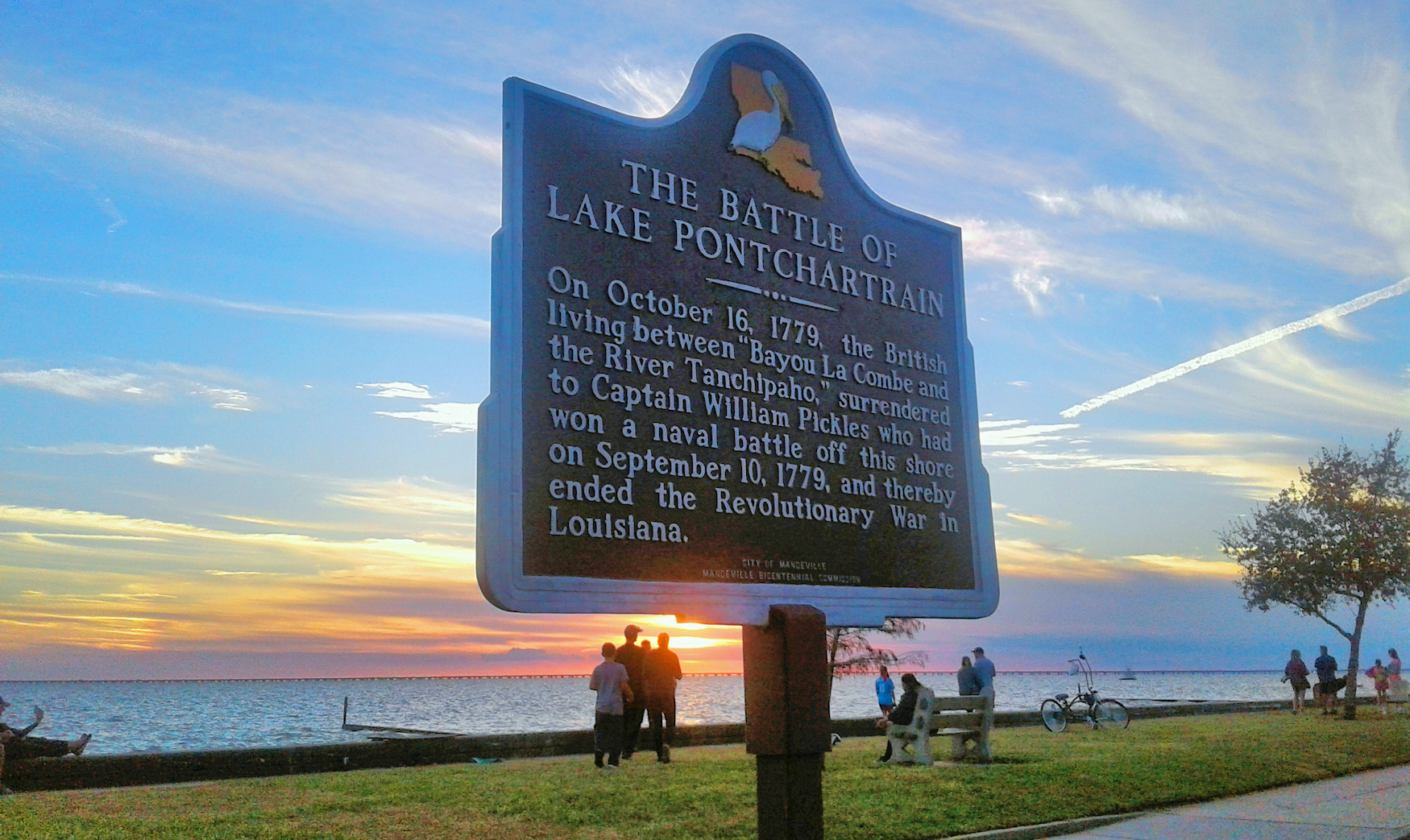
The "Battle of Lake Pontchartrain" Marker in its new location

The Bartram Trail marker in Pelican Park

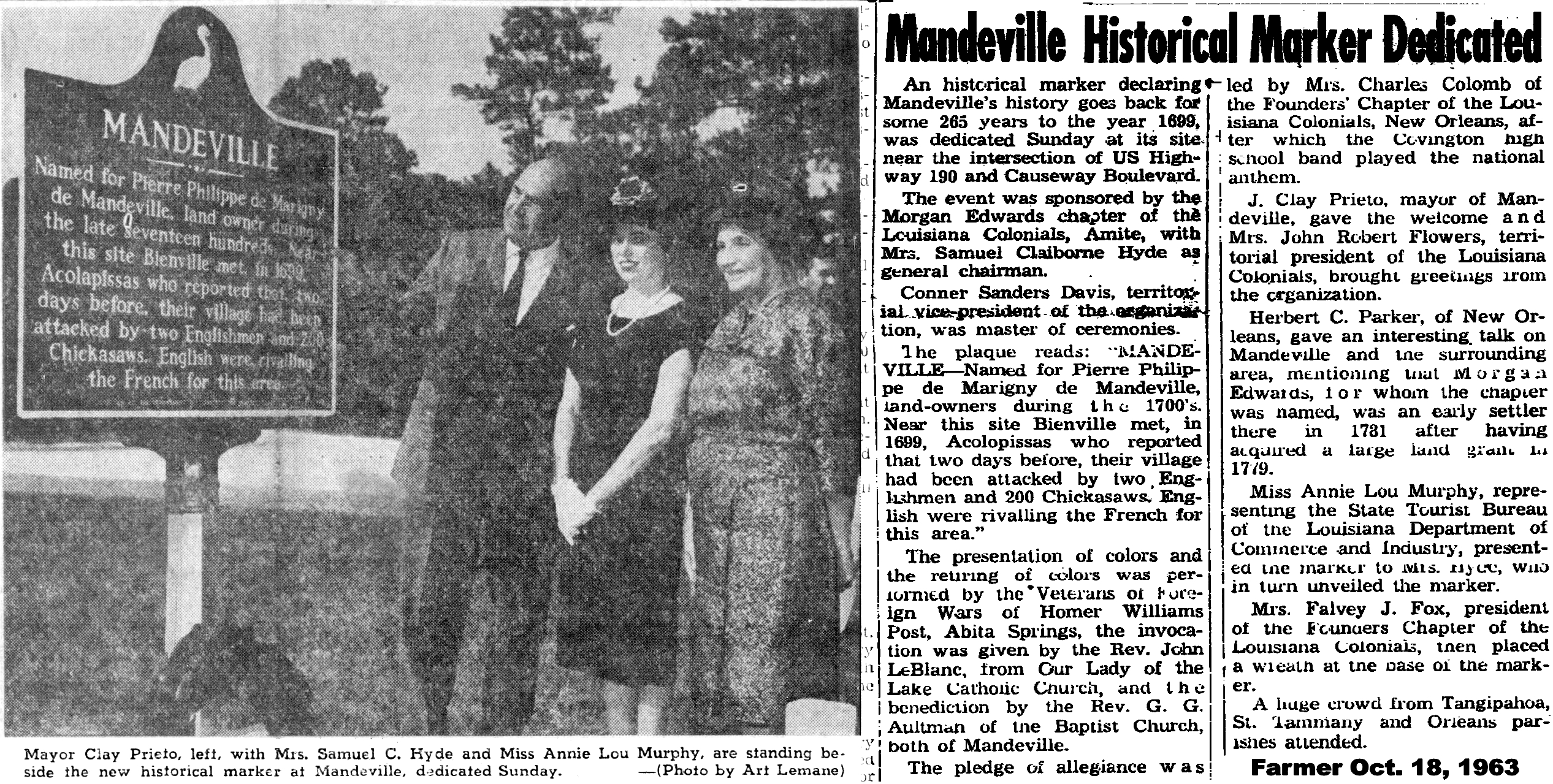
In 1699 Bienville visited the Colapissa Indians who lived in this area.
The Indians called the Pearl River "Taleatcha" ("rock river") because of
pearls found in shells from its waters. The French found the river
water good to drink.

Centennial Slidell
City of Slidell Centennial Nov. 13, 1888 - Nov. 13, 1988. Named for diplomate and U.S. Senator John Slidell of Louisiana by son-in-law Baron Frederic Erlanger, one of the financiers of New Orleans and Northeastern Railroad. Incorporated Nov. 13, 1888.
Dedicated To The Memory Of Those Who The Defense Of Our Country And All Who Served In The Cause Of Freedom
In 1907, Guido Alexius and his sons Alfred, Cintio and John, founded
Alexius Brothers and Company; and later his son Horace joined in the
business. In 1915, this landmark establishment, originally a gym, was
purchased. Later in the 20th century, Guido's grandsons G.C. and Haller Alexius operated the hardware store at
this location until 1985. In addition, portions of the land were donated
by the Alexius family for the construction of the Covington
Trailhead.
The Old Railroad Depot- The original depot faced New Hampshire Street with a passenger and freight terminal facing east. During the mid-1900s, the depot was moved one block to the present site (now a restaurant). The St. Tammany Special line left New Orleans at 4:30 p.m. and arrived in Covington at 6:15 p.m. It would leave Covington at 6:45 a.m. and arrive in New Orleans at 8:30 a.m. daily. This train was composed of elegant coaches and contained parlor buffet cars.
The Old Railroad Depot- The original depot faced New Hampshire Street with a passenger and freight terminal facing east. During the mid-1900s, the depot was moved one block to the present site (now a restaurant). The St. Tammany Special line left New Orleans at 4:30 p.m. and arrived in Covington at 6:15 p.m. It would leave Covington at 6:45 a.m. and arrive in New Orleans at 8:30 a.m. daily. This train was composed of elegant coaches and contained parlor buffet cars.

English side- Abbé Rouquette (1813-1887), poet and priest, lived
as missionary among Choctaw Indians in region of Bayou Lacombe from 1859
till his death. The Choctaw called him "Chata Ima," meaning "Like a
Choctaw."
French side"Abbé Rouquette (1813-1887), poéte et prêtre, vécut comme un missionair entre les Indiens Choctaws de la région Bayou Lacombe de 1859 jusqua'à sa mort. Les Choctaws l'appelérent "Chata Ima" qui est "comme un Choctaw."

Public "Ox Lot" Parking
French side"Abbé Rouquette (1813-1887), poéte et prêtre, vécut comme un missionair entre les Indiens Choctaws de la région Bayou Lacombe de 1859 jusqua'à sa mort. Les Choctaws l'appelérent "Chata Ima" qui est "comme un Choctaw."

Public "Ox Lot" Parking
Unique to Covington's downtown business district and a credit to our
forefathers, our original town grid layout allowed for public squares in
the middle of each block for the purpose of trade and commerce. Farmers
would bring their oxen-laden carts to town loaded with wares and conduct business in these designated
center block locations. Traditionally called "ox lots" and largely
responsible for Covington's designation as a national historic district,
today's use provides free public off-street parking for downtown
visitors and employees.

Founded July 4, 1876, H.J. Smith and Sons Hardware and Museum is the
oldest hardware and general store in the parish, housing unique
artifacts pertaining to the history of Covington. Of note are the dugout
cypress canoe and lead coffin. It is a regular stop for school field
trips. Cotton was brought in from north of town and Mississippi
plantations to be shipped to New Orleans. As many as 40,000-50,000 bales went through Covington in a year. The wagons pulled by teams of
oxen regularly lined Columbia Street from the cemetery to the landing.
The St. Tammany Fishing Pier was built from sections of the original
I-10 Twin Span Bridges which opened December 21, 1965. Tens of thousands
of cars used these bridges to cross Lake Pontchartrain between Slidell
and New Orleans until the morning of August 29, 2005 when Hurricane Katrina made its final landfall. A
storm surge in excess of 16 feet, combined with that water's return to
the Gulf of Mexico destroyed the twin bridges. This destruction became
one of the storm's most iconic images. St. Tammany Parish Government,
partnering with LA DOTD and the LA Dept. of Wildlife Fisheries, chose to
create a fishing pier as a new public use for the remnants of the
bridges and as a testament to the strength and resiliency of the
citizens who call southeastern Louisiana their home.
During the Reconstruction Period, trade was still slow as the main
source of land transportation was still the ox and the wagon. From the
mid-1800s, the railroads were primarily used access the area's vast
timber reserves, but once built, they were quickly put to use by the burgeoning tourism and resort industry. On May
16, 1888, the East Louisiana Railroad reached Covington, heralding an
economic boom. The flow of people and commerce that first came by river
exploded with the arrival of the railroad.
Three rivers and several Indian trails converged in the area where
Covington was founded. These major trade routes are what placed
Covington at the center of commerce. They became the lifeline of trade
and transport between points north of Lake Pontchartrain and the markets in New Orleans and beyond. When the bridges
periodically washed out from logs floating down the river, the community
would rally to restore these vital links.

Original Homestead of Walker Percy
Homestead owned by Walker Percy, who was an American author and philosopher. He is best known for his philosophical novels set in and around New Orleans, the first of which, The Moviegoer, won the U.S. National Book award for fiction. Walker Percy along with 21 other noted authors created the fellowship of Southern Writers.
Homestead owned by Walker Percy, who was an American author and philosopher. He is best known for his philosophical novels set in and around New Orleans, the first of which, The Moviegoer, won the U.S. National Book award for fiction. Walker Percy along with 21 other noted authors created the fellowship of Southern Writers.

Erected and Dedicated To The Soldiers Of World War I1920; Restored 2010 By St. Tammany Parish Kevin Davis, Parish President.
Columbia Street meets the river at the Columbia Street Landing. It was
the first place visitors saw when they arrived in Covington. It was also
the last stop on land for the area's principal exports on their way to
market via the Bogue Falaya River across Lake Pontchartrain to New Orleans. In 1890, Covington's new
town hall was situated in the ox lot in the middle of the square bounded
by Boston, Columbia, Rutland and Florida streets. This block of
Columbia Street naturally developed as the principal commercial area in
the town.
Andrew Jackson in Covington
Historical records indicated that General Andrew Jackson passed through Covington back in 1814 when it was still named Wharton, so the city put up a historical marker proclaiming that fact. Jackson was on his way to the Battle of New Orleans, which he won, forever changing the course of American history.

Claiborne Courthouse
The two story courthouse in Claiborne (Hill) was built in 1818 and served as the parish seat of government for approximately 18 years. Then the parish seat was moved across the river to Covington and a new courthouse was built. The historical marker was placed in 2025 across the driveway from the entrance to The Chimes Restaurant.

The steam engine on display in Houltonville is typical of many such engines employed
as portable power plants from the time of their introduction 1847
through the 1930's.
This engine was built by the Geiser Manufacturing Company of
Waynesboro, Pennsylvania, in 1908. This was their model "P", the largest portable engine the
Geiser Company ever made. Only 82 such engines were built, and this one
is the only known survivor.
The engine was put back into operating condition in 1970 and is capable of running the sawmill attached to it today.The sawmill presently attached to the steam engine is a movable sawmill made in Chattanooga, Tennessee, by the Corley Manufacturing Company, and is commonly called a groundhog mill.
Together with the steam engine it illustrates a small, country steam sawmill typical in America during the last half of the 19th-first quarter of the 20th-century. It was last owned and operated by the Varisco Brothers of Hammond, Louisiana.


Waldheim Church
Built be German Settlers, the Waldheim Methodist Church was dedicated September 12, 1875 as BONIFACE
CHURCH by The Rev. J.B.A. Ahrens, D.D.Presiding elder, Louisiana
District German Mission Conference of East Texas and Louisiana Methodist
Episcopal Church, South.Services in German and English for Many Years. TABERNACLE of the GERMAN SETTLEMENT CAMP GROUNDS --Erected
approximately 100 feet east of the Church under the leadership of THE
REV. GABRIEL R. ELLIS. First service held September 22, 1887. Annual Camp
Meetings which were held for 20 years drew thousands of persons to
worship.
Affectionately called Salmen Lodge by the Scouts, this French Creole
cottage was placed on the National Register of Historic Places in 2006
and is one of a few early structures preserved along Bayou Liberty.
Built by one of the early settlers with bricks made on site, evidence suggests this structure served as a
trading post for Native Americans and early Spanish and French settlers.
An 1885 property deed indicated the building was used as a store and
that a ferry and landing operated nearby.

The 130 acres of the Camp Salmen Nature Park were once part of the
Salmen Brick and Lumber Company. Many bricks used to build New Orleans
were manufactured on this site. The only remaining building in the camp
is of historical and architectural significance. It is a French Creole residence and one of only 26 buildings
in the parish which date before the Civil War. It has been named the
Salmen Lodge, and is on the National Register of Historic Places.
According to legend, in 1921 an unknown Boy Scout shared an umbrella with Fritz Salmen of the Salmen Brick and Lumber Company. The scout refused a tip, and this led to Salmen's company donating a 72.5 acre tract of land on Bayou Liberty for use as a scouting camp in 1924. In 1956, Fritz's son Fred donated another 35 acres adjoining Camp Salmen.
PRESENT CAMP SALMEN
Camp
Salmen was a Boy Scout summer camp for nearly 60 years. In 2001, St.
Tammany Parish entered into an agreement with the Trust for Public Lands
to acquire the property. One of the primary goals of the Camp Salmen
Nature Park is to restore a unique ecological treasure through a
comprehensive management program.
According to legend, in 1921 an unknown Boy Scout shared an umbrella with Fritz Salmen of the Salmen Brick and Lumber Company. The scout refused a tip, and this led to Salmen's company donating a 72.5 acre tract of land on Bayou Liberty for use as a scouting camp in 1924. In 1956, Fritz's son Fred donated another 35 acres adjoining Camp Salmen.
This will lead to the property being a
living museum, housing both restored historic properties and the full
collection of plants and animals which can flourish in this habitat. In
the Grotto Garden, visitors may enjoy a variety of native flora.The camp is
divided into six different management areas, according to the different
landscapes and habitats found within each. There are four trail loops
(called Interpretive Journeys) designated on the next map, and each
trail loop will bring visitors to one or more different landscapes.
Plants and animals native to these areas can be seen on the trail loops.
The Interpretive Journey trail system will include approximately 32,500
linear feet of interpretive trails and boardwalks. Educational signs
will guide hikers through the management areas and point out
environmental and historical points of interest.
These trails
will eventually link with the Tammany Trace, a 31-mile rails-to-trails
recreational corridor which connects the St. Tammany cities of
Covington, Mandeville, Abita Springs, Lacombe and Slidell.The ecological
management areas will allow for growth and development of a variety of
habitats, including a Long Leaf Pine Savannah.
The preservation of the park will create one of the most important educational tools in Southeast Louisiana. The park will eventually provide a Welcome and Nature Center, with rooms available for instruction and presentations.Please enjoy the history and ecological treasure that is Camp Salmen Nature Park.
This Tablet is erected in memory of Fritz Salmen - A pioneer industrialist
who in 1924 gave this land to be used as a Boy Scout camp site. Dedicated
to the development of good citizenship of American youth.
This sugar mill in Fontaintebleau State Park operated similarly to other steam-powered mills of the
mid 1800's. Molasses was drawn out of raw sugar cane by heating it in
five kettles known as the "batterie." The cane juice was transferred
from the largest kettle called the ""grande" into the next four kettles repeatedly until the sugar was partially crystalized (sic).
Then the sugar is transported in a series of troughs and cooled for 24 hours. The sugar was then put into hogshead barrels with holes on the bottom called Potting-casts. Each hole in the Potting-cast was plugged with crushed cane which drew the molasses away from the sugar and into a cistern. After the molasses was drained away the hogshead barrels of sugar could be shipped by rail or canal to barges on Lake Pontchartrain.
Then the sugar is transported in a series of troughs and cooled for 24 hours. The sugar was then put into hogshead barrels with holes on the bottom called Potting-casts. Each hole in the Potting-cast was plugged with crushed cane which drew the molasses away from the sugar and into a cistern. After the molasses was drained away the hogshead barrels of sugar could be shipped by rail or canal to barges on Lake Pontchartrain.

Resting place of pre-Louisiana Purchase colonial settlers, veterans of
the War of 1812 and the Civil War, and many men and women of great
importance to local and national history.

The Southern Hotel

The Southern Hotel
At the turn of the 20th century, Covington was famous for its healthful,
healing environment. Excursionists came by schooner and by rail to
breathe the pine-scented air and drink the pure waters. To accommodate
the many guests, Covington, like other towns on the north shore, offered a selection of hotels and home-like
resorts. The Southern Hotel opened its doors on June 1, 1907. The
hotel, designed in the shape of the letter "H," was constructed at a
cost of $100,000. The chef and his assistants were formally in the
employ of first class hotels and restaurants in New Orleans. There were
200 feet of galleries overlooking New Hampshire Street, a formal garden
and a tennis court. Tame and exotic animals resided in cages in the
central lobby surrounding an artesian fountain. The building houses
government offices from the 1980's until a few years before its
restoration began in 2012. …
John Slidell was an American politician and diplomat. Born in New York
City in 1793, he later moved to New Orleans, where he practiced law from
1819 to 1835. He married Mathilde Deslonde, a member of a respected
family. A member of the state House of Representatives, John Slidell
unsuccessfully ran for Congress in 1828, but held the office of U.S.
District Attorney from 1829-1833.
He was then elected as States Rights
Democrat to the 28th and 29th U.S> Congress and served from March 4,
1843 until his resignation on November 10, 1845. In 1850, Slidell was
elected to the U.S. Senate. He was reelected in 1853 and became a major
influence in the administration of President James Buchanan.
At one
point, he was known as "the most powerful man in the United States"Upon
Louisiana's secession from the Union, Confederate President Jefferson
Davis appointed Slidell as a special envoy to France with a mission of
seeking diplomatic assistance and procuring war resources. While on his
mission, Slidell was taken from the RMS Trent, which was seized by the
U.S. After his release, he arrived in Paris in January 1862.
Through the
banking house of Baron Emile Erlanger, Slidell arranged a major bond
issue for the Confederacy. He remained in Europe after the Civil WAr. He
died on July 29, 1871, in Cowes, Isle of Wight, England.

In the course
of Slidell's diplomatic and banking transactions, his daughter Mathilde met
and married Baron Emile Erlanger's son, Frederick. Frederick Erlanger
succeeded his father as Baron and participated in building the New
Orleans and Northeastern Railroad. He named the first settlement in
honor of his father-in-law, John Slidell.
Slidell, Louisiana was founded in 1883 during construction of a major
new railroad from New Orleans to Meridian, Mississippi. The New Orleans
and Northeastern Railroad established a building camp at first high
ground north of Lake Pontchartrain which eventually grew into the city. Slidell was chartered as a town in
1888 by the Louisiana Legislature.
The town was named after John Slidell, a prominent state, U.S. and Confederate political figure. Sometime prior to Slidell's formal incorporation in 1888, its first streets were laid out in a grid pattern. The north-south streets were Bayou (now Front), First, Second, Third and Fourth. The east-west streets were Fremaux, Erlanger, Bouscaren and Cousin.Erlanger, slightly wider than the others and designated as an avenue, was named after Baron Frederick Erlanger, John Slidell's son-in-law and head of the banking syndicate which financed the railway.
Col. Leon J. Fremaux, a prominent Louisiana engineer and planter, drew the original plans for Slidell and named Fremaux Avenue for himself. Bouscaren Street was named for G. Bouscaren, the chief engineering officer of the railroad. Cousin Street took its name from the locally prominent Cousin family.
In the thirty or so years after its founding, Slidell developed a creosote plant, one of the country's largest brick manufacturing facilities, a large lumber mill, and a shipyard. The Slidell Shipyard contributed significantly to the nation's effort in both World Wars. Slidell residents worked in a local ship, tank and airplane construction during World War II.
In the 1960's Slidell began to assume its modern profile as one of the major sites for NASA's lunar landing program. In the 1980's and 1990's Slidell became a regional retail center.Slidell is located at the southeastern tip of St. Tammany Parish in Louisiana's famous "Ozone Belt." It is about three miles from the north shore of Lake Pontchartrain and is surrounded by rivers and bayous.
The largest municipality in the Parish, Slidell has grown from a population of 364 in 1890 to 24,142 in 1990. Slidell's 1999 population is estimated to be 32,000. Today, Slidell continues to deal with urban growth while preserving a sense of its history.
Flags Over Slidell. The United States of America 1810-1860:1865-PresentII. The State of Louisiana 1812 - PresentIII. The City of Slidell 1888-Present1. The Kingdom of France 1682-17632. The United Kingdom (Great Britain) 1763-17833. The Kingdom of Spain 1783-18104. The Republic of West Florida 18105. The The Republic of Louisiana 18616. The Confederate States of America 1861-1865 …

Oldest Methodist Assembly in Slidell. Founded in a brush arbor on Sept.
26, 1887, as Methodist Episcopal Church South. Joined the Louisiana
Conference in 1894. Present site dedicated July 16, 1961.
In 1883, Baron Erlanger named our city in honor of his father-in-law,
John Slidell. Slidell had been a confidant of two American Presidents
and a powerful member of the U.S. Senate from which he resigned in 1861,
when Louisiana seceded from the Union. Confederate President Jefferson Davis appointed him commissioner to
France. Slidell nearly succeeded in bringing France and England to the
assistance of the Confederate States of America. Had he been successful,
the war between the States would have taken a different course. After
the collapse of the C.S.A., Slidell never returned to Louisiana. He and
his family are buried in Villijuif, France.
Named for diplomat and U.S. Senator John Slidell of Louisiana by
son-in-law Baron Frederic Erlanger, one of the financiers of New Orleans
and Northeastern Railroad. Incorporated Nov. 13, 1888.

Built in 1907, this building replaced the original wooden Jail and
Mayor's Office. It was Town Hall until 1954 and the Jail until 1963. The
town's fire engine was located in the addition from 1928 until 1954.
Fontainebleau Plantation Sugar Mill
Fontainebleau Plantation Sugar Mill
These ruins are all that remain of Fountainebleau Plantation, once the
summer home and plantation of Bernard de Marigny. Born in 1785 to a
family closely tied to the earliest colonial efforts in Louisiana,
Marigny accumulated and lost a fortune in his lifetime. The grounds that make up Fountainebleau State Park are
just a part of the vast land holdings he acquired on the north shore of
Lake Pontchartrain. He operated Fountainebleau Plantation, brick kilns
and a sugar mill between 1828 and 1852.
Although his major residence was in New Orleans, he chose to spend much of his time at his summer residence, cooled by the breezes of the lake and free to enjoy the simple pleasures of life. During his ownership of the plantation he participated in the early development of sugar cane and the refinement of sugar. The nearby town of Mandeville was owned and developed by Marigny as part of his extensive real estate interests. An unsuccessful candidate for governor three times, he remained active in politics until his death in 1868.

Courthouse Square and Historic Oaks Historical
Courthouse Square and Historic Oaks These graceful oaks were planted
hundreds of years ago, predating the street plan of 1813. The WWI
monument seen in the image on the right is all that remains at this site
following the demolition of the old courthouse in 1958.As the parish (county) seat since 1819,
Covington was the center of commerce, industry and government on the
north shore for many years. The first courthouse was built on the east
side of the Bogue Falava River at what is now called Claiborne Hill. The
location was later moved to this site where a more permanent brick
courthouse was built in 1885. It served until it was replaced by the
"modernized structure" which ws completed in 1960. The St. Tammany
Parish Justice Center was constructed just up the street in 2003.


Probably the most significant economic development, not only for
Covington but for the parish as a whole, was the establishment of the
bank. The Covington Bank & Trust was established in these original
quarters. It is the oldest commercial building in Covington.Two fires destroyed most buildings built before 1880.
Rebuilt shortly after the Great Fire of 1898, the downtown buildings
provide a beautiful example of turn-of-the-century commercial
architecture. In 1909, there was a fireman's parade, which included
several fire companies. These organizations united to form the Covington
Fire Department.

(Photo credit: Historical Marker Database)
The original 23.86 mile-long structure, which now carries the Southbound
traffic, was designed by the firm of Palmer & Baker. When opened in
1956, the structure was the longest bridge in the world by more than 15
miles. In building the bridge, which took just fourteen months, assembly-line, mass-production methods
were utilized for the first time in the construction of a bridge. It was
designed to employ hundreds of identical, hollow concrete pilings,
concrete caps, and pre-stressed deck sections manufactured at an
on-shore facility and barged into place. Engineering News-Record acclaimed the project to be "a bold venture requiring unusual foresight, ingenuity and resourcefulness."
Opened: August 30, 1956
Dedicated: October 18, 2003
Opened: August 30, 1956
Dedicated: October 18, 2003
These six men of the 2nd Division 13th Regiment Louisiana Militia fought
at the Battle of New Orleans during the War of 1812 and are buried in
unmarked graves Auguste Badeaux, Samuel Ott, William Cooper , Charles Parent, Jr. James Johnson and Lawrence Sticker
One of two lines of fortifications excavated from January to March 1864
by Union forces "on fatigue duty" soon after their capture of
Madisonville. Intended to defend the town from Confederate attacks
coming from the surrounding countryside. The earthworks originally consisted of a trench protected by an "abatis" or
barrier of felled trees with sharpened ends laid pointing out along its
edge. The line meandered from approximately Rene and Covington Streets
in a westerly direction to about this point on Johnson Street. Property
records for the lot adjacent to this site mention "breastworks" on the
land from the 1870s forward. Madisonville was occupied to obtain war
supplies in the form of timber, lumber, logs, turpentine, tar and bricks
for the federal Department of the Gulf.

Built 1846 by Jonathan Arthur of London for descendants of English
settlers in British West Florida. Consecrated by Bishop Leonidas Polk,
April 11, 1847. Christ Church is the oldest public building being used
in Covington.
At 23.87 miles long, the Causeway is the world's longest bridge over water. The
first span was completed in August 1956. Due to increased traffic, a
second span opened in May 1969. The Causeway piloted major construction
of prefabricated, prestressed concrete bridges in the United States. It
is supported by more than 9,000 pilings. Construction of the Causeway
expanded the Greater New Orleans area to include the northshore of Lake
Pontchartrain.

An active harbor where schooners and steamers once docked. Established
in the early 1800's, providing a vital link to other river cities
transporting cotton, lumber, bricks, whiskey and mail. Oyster luggers
brought fresh oysters regularly through the late 1930's. Many early settlers of the community arrived at this destination.

St. Tammany Parish was among the Spanish-governed West Florida parishes
and not included in the Louisiana Purchase of 1803. Residents revolted
against Spanish rule September 1810, creating the Republic of West
Florida. The republic lasted 74 days, raising a new flag and electing a president, before being forcibly annexed by the U.S. in December 1810.

Originally called "Cokie" (from Coquille) because of the abundance of
shells in the area. Renamed for Pres. James Madison, c. 1811. Site of
Navy Yard in early 1800's. According to legend, Gen. Andrew Jackson,
enroute to New Orleans in Nov. 1814, stopped here at the home of Gen. David B. Morgan.


With Community Center in background
Saint Peter Church Historical
L'Abbé Jouanneault built the predecessor of St. Peter Church on the Bouge Falaya in 1843. The first resident pastor was Fr. J.M. Giraud, appointed in 1863 to serve Covington, Madisonville, Bedico, and Abita Springs. In 1892 Fr. Joseph Koegerl, pastor, who was also Canon of St. Louis Cathedral, built a new church and rectory on Massachusetts St. The Jefferson Ave. church was erected in 1940 during the pastorate of Fr. Aemillian Egler, O.S.R. Two Benedictines have served the parish continuously since 1922.

On October 16, 1779, the British living between "Bayou La Combe and the
River Tanchipaho," surrendered to Captain William Pickles who had won a
naval battle off this shore on September 10, 1779, and thereby ended the
Revolutionary War in Louisiana.
Unique to Covington's downtown business district and a credit to our
forefathers, our original town grid layout allowed for public squares in
the middle of each block for the purpose of trade and commerce. Farmers
would bring their oxen-laden carts to town loaded with wares and conduct business in these designated
center block locations. Traditionally called "ox lots" and largely
responsible for Covington's designation as a national historic district,
today's use provides free public off-street parking for downtown
visitors and employees.

Old Choctaw village which derived name from nearby medicinal springs.
Last Choctaw burial and execution grounds, used until about 1880,
located nearby.
Early in the eighteenth century, Catholic missionaries evangelized
Choctaw, Chinchuba and other Indian tribes and sub-tribes on the
northern shore of Lake Pontchartrain, among pioneer priests was Fr.
Michael Baudouin, S.J., superior of the Jesuit Mission in Louisiana and Vicar General to the Bishop of Quebec, Canada.
Fr. J. Outendrick was the first resident pastor when the Mandeville
Congregation was organized in 1850. Fr. Adrien E. Rouquette,
"Chahta-Ima," also labored here and elsewhere in St. Tammany Civil
Parish. The present church was dedicated in 1953 during the pastorate of
Fr. Canisius Bluemel, O.S.B., one of several Benedictines serving here
since 1890.

Walker Percy Historical
Covington resident, where he wrote, among others, Lancelot, The Second Coming, Love in the Ruins, The Thanatos Syndrome, The Last Gentleman, and The Moviegoer, which won the National Book Award for fiction, co-founder Fellowship of Southern Writers, graduate of the University of North Carolina, buried at St. Joseph Abbey, 3 miles north. Google Maps

This historical marker was placed in Bogue Falaya Park in Covington in August of 2018 to commemorate a new statue of Walker Percy .Also, several historical plaques were placed in front of the Madisonville library to spotlight Walker Percy's many literary contribuitons. CLICK HERE to see those plaques, which accompany another statue of the famed Covington resident.
CLICK HERE to go to webpage containing the above list.


A Madisonville area historical marker
Go To Index


A Madisonville area historical marker
Go To Index