

Sunday, July 31, 2016
Slidell Baptist Church
A photograph of the Slidell Baptist Church in its early days. It was organized with 11 members and built on land donated in 1892 by Fritz and Rosa Salmen. Click on the image below to see a larger version.

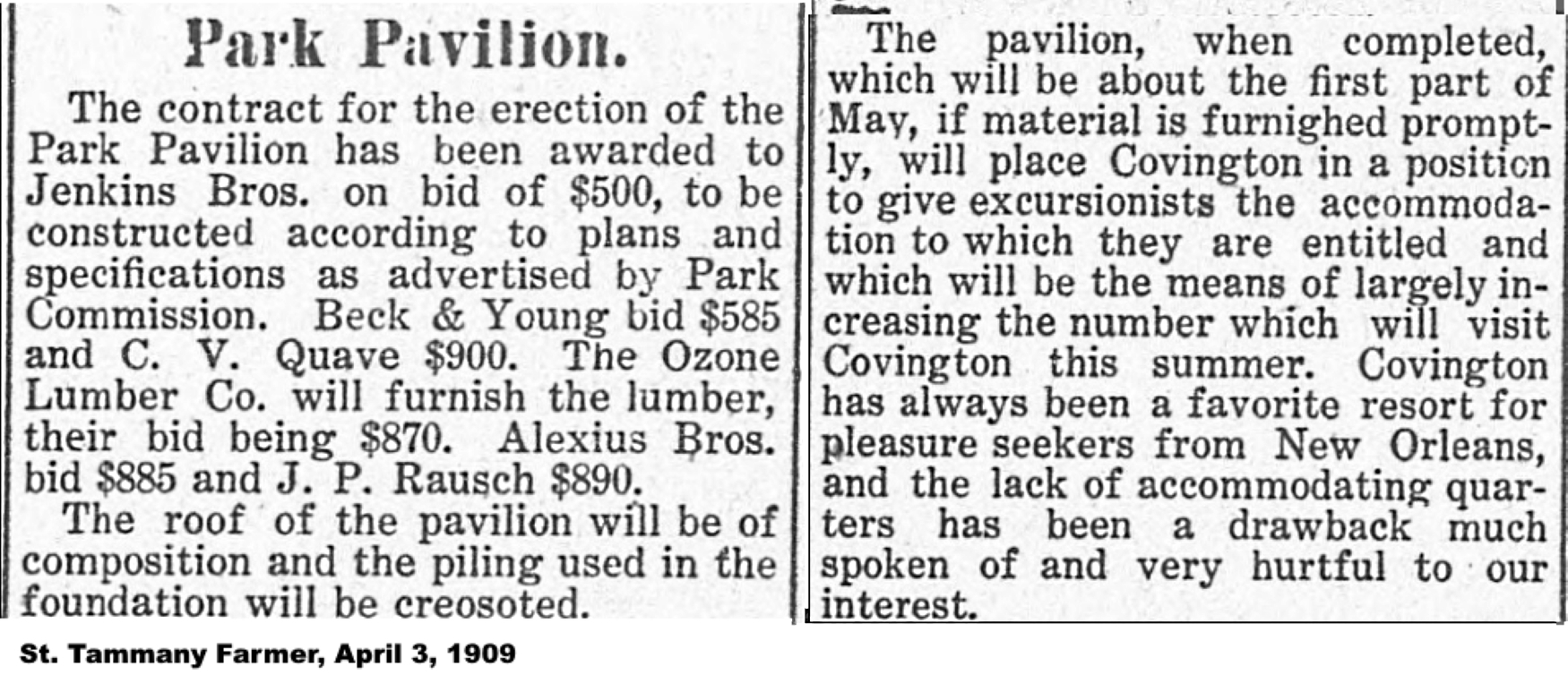
Bogue Falaya Park Pavilion
Over the past 100 years, the pavilion at Bogue Falaya Park in Covington has played an important part in the community's activities, both as a spot for special events as well as a place to just enjoy the trees and the river.
The first park pavilion was building in April of 1909, and the park itself opened a couple of months later.
Here is a series of photographs of the park pavilion, in its various manifestations, since it tended to get rebuilt after every flood that seriously damaged it or wiped it away completely. Click on the images below to make them appear larger.


Eating watermelon at the park pavilion


Flood damage in the 1920's (above)


Over the years the pavilion has been used for a large variety of purposes, including field trips for local groups of school children.


--------------------------------------------------------------
The Documentation for Placement on the
National Registry of Historic Places
On August 17, 2017, Bogue Falaya Park was placed on the National Registry of Historic Places. The narrative description of the park listed on the NRHP application went as follows (with some editing):
Within the park are two significant structures, the main being the pavilion situated at the end of the turning circle/ parking lot area within the park. The dominant feature of the park, the current pavilion was constructed in 1915 and has acted continuously as an important community gathering center for the city of Covington.
The Bogue Falaya Park is significant for recreation and entertainment as the park has provided a recreational space that was not only used by locals, but residents of New Orleans as well, for over 100 years. The historic resources within the park have been continually used by residents and visitors and retain a high degree of integrity.
Due to the relative health of the city of Covington and the access to the river, recreation became a large part of the Bogue Falaya and its banks. The land for the park was bought from G.R Tolson in 1908 by the City of Covington to establish a 13-acre park. The park was officially opened on July 1st, 1909. The city maintained the park from that time until 1938 when it was gifted to the State of Louisiana who managed it until 1978 when it was given back to Covington.
The original pavilion was constructed in 1907 and was destroyed in a storm in 1915, which necessitated the building of the existing structure. Even prior to the formal designation of the park, this original pavilion and riverbank area was a popular destination and a source of pride for residents and a featured tourism spot.
Multiple post cards were developed in this time with renderings and photographs of the pavilion. One shows visitors walking to the pavilion with their buggies parked in the grass.
Up until the 1960s, the park was a popular swimming spot for the residents of Covington, and on the weekends, residents of New Orleans. The pavilion was used as a gathering space for visitors to the park. The pavilion offers an open space for people to gather under and, when the park was still open for swimming, it offered a counter where you could purchase a basket of swimming essentials.


Behind the counter were showers and changing areas for swimmers. In the front, to the left-hand side was a concession stand where visitors could buy an assortment of refreshments. A jukebox was also in the pavilion. During the period of significance, the pavilion and park were open all night and became a place for teenagers to dance.

The Bogue Falaya Park is significant because of the popularity of the park among residents of Covington and the pivotal role the pavilion played in providing services, entertainment, and a break from the heat during a time when tourism and recreation on the Northshore was at an unsurpassed rate. This park provided the main recreational access to the river and was a true center of the community during the hot months. The park and pavilion were also used for private family parties and gatherings as well as public town events throughout the year.
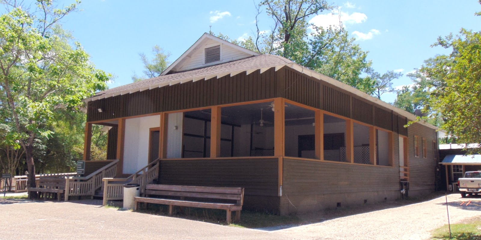
The Pavilion
The original pavilion was built in 1907 and was destroyed in a storm in 1915. The existing pavilion was constructed that same year to replace the damaged original. The pavilion is a free-standing wood construction building located at the end of the parking lot turning circle and serves as the focal point in the park.

The pavilion is a one-story structure and is dominated by a large open air room. A set of five wooden stairs with a railing on both sides brings visitors up to a small inset doorway with wood trim painted the color tan. The interior space from the front entrance opens into a large square area with low wooden benches along the perimeter.
The back wall contains two sets of double doors, behind which is now storage/prepping area. This space was originally where visitors would rent swimming equipment and housed the changing areas for each sex. To the right and left of these doors are the current restrooms. A later addition, on the back-left section of the pavilion facing the back wall is a handicapped accessible restroom. To the left of the main structure is a low side addition, which used to serve as the concession area. The building retains a high degree of historic integrity for location, setting, design, materials, workmanship, feel and association. It has been continually used by the community for over 100 years and its historic features have been retained while also updating certain aspects of the building for modern uses. The pavilion is over 50 years old and retains much of its integrity from its construction in 1915, with some modifications and upgrades as stated above.
Today, the park is used daily by locals and visitors alike. The pavilion is still available for private rental for celebrations and gatherings and is often booked. Town-organized events are also held in the structure, such as the philharmonic music event series and the Halloween Monster Mash.
The park is a source of joy and pride for all the residents of Covington and remains an important asset to the community. The Bogue Falaya Park has served as a key recreational facility in Covington since it was first created in 1907-08.
See also:
Saturday, July 30, 2016
The St. Tammany Special Train
Early in the 20th century, Covington commuters who made the daily trip to New Orleans were served by railroad in addition to lake steamer.
The "St. Tammany Special" was a train made up of several cars that made daily trips between New Orleans and Covington. Its schedule called for it to leave New Orleans at 4:30 p.m. each day (except Sundays), arriving in Covington at 6:15 p.m. The train would then leave Covington the next day at 6:45 a.m. and arrive back in New Orleans at 8:30 a.m.
The trains were comprised of "elegant vestibule coaches and Parlor Buffet Cars."

The St. Tammany Special
There was also a local train that left New Orleans each morning (except Sundays) at 6:30 a.m. and arrived in Covington at 9:30 a.m.
On Sundays and Wednesdays, there were "Excursion Trains" that left New Orleans at 7:40 a.m. and arrived in Covington at 9:55 a.m. They would leave Covington to head back to New Orleans at 4:55 p.m.

A 1927 Advertisement
On the "Remember Covington..the way it was..way back when..."Facebook page, John Grey said the St. Tammany Special began operating on May 27, 1903 to give "comfortable and quick access to the balmy resorts of the Ozone Belt."
In a newspaper article published at the beginning of the train's service, Grey read that "it was one of the first suburban trains in commission in the country. It ran the day before as a celebration with invitations from the N. O. & Northeastern and East Louisiana officials to rarlroad and newspapermen to make the initial trip. In some stretches the train made a speed of over 60 mph."
Grey goes on to quote the article as saying the train was ventilated from one end to the other and consisted of a combination baggage and club car and three modern coaches. "The windows on the club were practically continuous making for a good view. It was fitted with the most comfortable type of easy chairs, and breakfast was served in the club car, consisting of coffee and eggs, cold meats and relishes and all kinds of drink.The club and coaches were finished in quartered oak," the article noted.
Then a few years later in 1930, the Covington to New Orleans route was home to "The Torpedo," a Red and Silver Flyer, that made the daily run.

Click on the above article to make it larger.
Cornstalk Fence
Cornstalk fences (and various variations thereof) were popular in New Orleans long ago, and even several early St. Tammany residences were adorned with the unusual enclosures and gates. Here's a picture of a section of cornstalk fence near the end of Riverside Drive. Click on the image to see a larger view.


This old postcard shows a section of a cornstalk fence in the New Orleans French Quarter

Friday, July 29, 2016
Sign Dedication at the Park Entrance
This photo shows the dedication of a new sign at the Entrance to Bogue Falaya Park, Covington, on July 2, 1993. It duplicated a sign that had been located there many years ago, reminding visitors not to litter, but it quoted an old saying rather than giving a harsh warning. The new sign was paid for by funds donated by the sale of music cassettes featuring locally-written songs about the rivers of St. Tammany Parish.

Here is the group at the 1993 dedication for the new sign, and below is a photograph of the original sign at the park entrance. In the old photograph are C. J. "Cyp" Schoen at left, Ronnie Pogue on top, and Beverly Thibodeaux. The photograph was supplied by Carlos Aceves.

The original sign was eventually covered with vines and had to be removed. Originally, Bogue Falaya Park was a "roadside" park owned by the State of Louisiana. When it was no longer needed by the state, plans were made to sell it to the public in 1979. So the park site might have become private property or a condominum complex at that time, if the city hadn't stepped in and acquired the park property.
However, city officials did not have the funds needed to maintain the facility, so the park gates were closed until the city could afford to keep it up. "So we acquired the property and just sat on it," said Councilman Donald Primes. Once city funds started to come in to begin improvements to the park, it was opened for public use. The new sign was built with materials from Poole Lumber Company with the design based on the photograph shown above.
Helping with the installation of the sign was a crew from CLECO, including Bucky Jakins, Paul Sheridan, Frank Gendosa, and Weldon Foxworth. Sign Services of Covington provided the painting of the sign and helped in its installation.
To see a video of the sign being dedicated, click on the video "play triangle" below.
Donald Primes tells about the history of the park and its restoration

CLICK HERE FOR A LINK to Roseanne Bivens
singing her song "Bogue Falaya Blues"
PROGRAM
for the Sign Dedication Ceremony

For more information about the 1984 reopening of the park, click on images below.


Here's how the entrance to Bogue Falaya Park looked many years ago.
The entrance gate built in 1920 served pedestrians, but was modified a few years later to accomodate cars. The two pillars on either side of that gate were retained. They were restored in 2007 along with the historical marker that was placed on them originally.


On January 24, 1920, W. L. Stevenson wrote a letter to the St. Tammany Farmer proposing that the above brick entrance pillars be built.


From left to right: Roseanne Bivens (on guitar), John Poole, Matt Faust, Donald Primes, Keith Villere, Ronnie Pogue, Diane Winston (elevated at back), Jan Robert, Carlos Aceves, Pat Clanton, Carol Jahncke, Lynn Moore and Ron Barthet.
See also:
Bogue Falaya Park
Bogue Falaya Park Playground Build
Tchefuncta Country Club History
Here's a brief history of how one of the area's earliest residential subdivisions, Tchefuncta Country Club Estates, came to be.

"Tchefuncta Country Club", encompassing 900 acres on the Tchefuncta River, 38 miles from New Orleans, was developed with miles of winding paved roads, its own sewer and water systems, underground utilities, with construction starting on a golf course and country club— all before the first home was built— without any tax money and without any promoter seeking a profit.
The country club's unique story begins with a lunchtime conversation between two young men in the New Orleans Petroleum Club. It was spring 1956, the causeway across Lake Pontchartrain was under construction. The two found that they had each been looking at property where the causeway was going, thinking of a home in the country among the trees, possibly on a river.
Search for a Site
The next few weeks were spent looking at sites and talking to friends who were also interested in more spacious living — with enough land for a golf course, horse trails, swimming, fishing etc. In June, the small group found a tract on the Tchefuncta River known as "Emfred". This beautifully wooded site was owned by Emma and Alfred Suter of Bogalusa who used it as a country place.
The group was enthusiastic and negotiated an option. The next few days were spent cajoling friends into putting up $50 each for the $6000 option money. Then the battle cry became "If 120 people put up $2000 each we can buy the property and put in roads." Original plans were not elaborate. Each person was going to put in his own water and a septic tank. A meeting was called at the Petroleum Club to get the ideas of the group and make plans. Thus was born Tchefuncta Club Estates Inc. A Board of Directors was elected, the land purchased and development started.
Problems On Every Front
A professional engineering firm was employed to assist in planning and developing the area. Committees of the co-owners worked on various phases of the development: Country Club and recreational area construction, roads, sewerage, water, utilities etc. There was even a committee to name the streets! There were legal problems, tax problems, right of way problems — these amateur developers for example discovered why most commercial projects have straight streets instead of winding roads — each time you bend a sewer line you must have a man hole at considerable additional cost.
All the time and effort of committee and board members were put in with no compensation except the dream of an ideal home and surroundings. Some of these men never realized the fruits of their labors — oil companies transfer personnel. Of the original 15 on the organization committee only seven reside in the community now and two still own lots.
Start of Construction
The fall of 1956 saw the start of construction and the start of the rains! Tchefuncta-ites will tell you that the three years from 1957-59 were the rainiest in history. But neither rain, nor mud, nor delays daunted the spirits of the Tchefuncta pioneers! Many members of the group moved to Covington, a town four miles from Emfred, to watch progress and be ready to build at the earliest possible time. One family rented the old Suter home and ploughed through three years of muck and construction just to enjoy the advantages of the great outdoors and watch their dream grow!
The first 144 persons who joined in taking the original option had first selection of the building sites and names were drawn from a hat to determine order of selection. The second group, from 144 to 246 also drew from a hat to determine their order of selection. Time limits were set on each group and one would see whole families tramping the woods to find their preferred dream spot, afterwards picnicking under the moss-hung trees or swimming in the river.
Subdivision Project Completed
In late 1959 the project was completed. The first resident moved in March 1960 and the Club House was completed in 1961. Now Tchefuncta has 11 miles of winding roads, central water and sewer systems, underground utilities, large wooded sites (minimum 150' x 200'), 250 acres of Country Club and recreation area featuring a club house, tennis courts, AAU size swimming pool, yacht harbor and docks, boat launching ramp, picnic and game areas, horse stable, golf course, golf driving range, fishing, boating and water skiing — the "very desirable residential sites with complete family recreational facilities" have become a reality.
Tchefuncta originated with a group of oil men, but other-business and professional men joined early in the venture. Now the population consists of a cross section of professions.


For more information about the estates, CLICK HERE.


See also:
Mr. and Mrs. Kent McWilliams Jr.

THE TCHEFUNCTA STORY
"Tchefuncta Country Club", encompassing 900 acres on the Tchefuncta River, 38 miles from New Orleans, was developed with miles of winding paved roads, its own sewer and water systems, underground utilities, with construction starting on a golf course and country club— all before the first home was built— without any tax money and without any promoter seeking a profit.

Click on the image to make it larger.
The country club's unique story begins with a lunchtime conversation between two young men in the New Orleans Petroleum Club. It was spring 1956, the causeway across Lake Pontchartrain was under construction. The two found that they had each been looking at property where the causeway was going, thinking of a home in the country among the trees, possibly on a river.
Search for a Site
The next few weeks were spent looking at sites and talking to friends who were also interested in more spacious living — with enough land for a golf course, horse trails, swimming, fishing etc. In June, the small group found a tract on the Tchefuncta River known as "Emfred". This beautifully wooded site was owned by Emma and Alfred Suter of Bogalusa who used it as a country place.
The group was enthusiastic and negotiated an option. The next few days were spent cajoling friends into putting up $50 each for the $6000 option money. Then the battle cry became "If 120 people put up $2000 each we can buy the property and put in roads." Original plans were not elaborate. Each person was going to put in his own water and a septic tank. A meeting was called at the Petroleum Club to get the ideas of the group and make plans. Thus was born Tchefuncta Club Estates Inc. A Board of Directors was elected, the land purchased and development started.
Problems On Every Front
A professional engineering firm was employed to assist in planning and developing the area. Committees of the co-owners worked on various phases of the development: Country Club and recreational area construction, roads, sewerage, water, utilities etc. There was even a committee to name the streets! There were legal problems, tax problems, right of way problems — these amateur developers for example discovered why most commercial projects have straight streets instead of winding roads — each time you bend a sewer line you must have a man hole at considerable additional cost.
All the time and effort of committee and board members were put in with no compensation except the dream of an ideal home and surroundings. Some of these men never realized the fruits of their labors — oil companies transfer personnel. Of the original 15 on the organization committee only seven reside in the community now and two still own lots.
Start of Construction
The fall of 1956 saw the start of construction and the start of the rains! Tchefuncta-ites will tell you that the three years from 1957-59 were the rainiest in history. But neither rain, nor mud, nor delays daunted the spirits of the Tchefuncta pioneers! Many members of the group moved to Covington, a town four miles from Emfred, to watch progress and be ready to build at the earliest possible time. One family rented the old Suter home and ploughed through three years of muck and construction just to enjoy the advantages of the great outdoors and watch their dream grow!
The first 144 persons who joined in taking the original option had first selection of the building sites and names were drawn from a hat to determine order of selection. The second group, from 144 to 246 also drew from a hat to determine their order of selection. Time limits were set on each group and one would see whole families tramping the woods to find their preferred dream spot, afterwards picnicking under the moss-hung trees or swimming in the river.
Subdivision Project Completed
In late 1959 the project was completed. The first resident moved in March 1960 and the Club House was completed in 1961. Now Tchefuncta has 11 miles of winding roads, central water and sewer systems, underground utilities, large wooded sites (minimum 150' x 200'), 250 acres of Country Club and recreation area featuring a club house, tennis courts, AAU size swimming pool, yacht harbor and docks, boat launching ramp, picnic and game areas, horse stable, golf course, golf driving range, fishing, boating and water skiing — the "very desirable residential sites with complete family recreational facilities" have become a reality.
Tchefuncta originated with a group of oil men, but other-business and professional men joined early in the venture. Now the population consists of a cross section of professions.


For a map showing where Tchefuncta Country Club is located, CLICK HERE.
For more information about the estates, CLICK HERE.


Tchefuncta Country Club Estates - 2018
Mr. and Mrs. Kent McWilliams Jr.
Subscribe to:
Posts (Atom)