In 1955 the old Pearl River Courthouse was moved to a Lions Club community playground to use for storing sports equipment.

Click on the above image to make it larger.

In 1955 the old Pearl River Courthouse was moved to a Lions Club community playground to use for storing sports equipment.
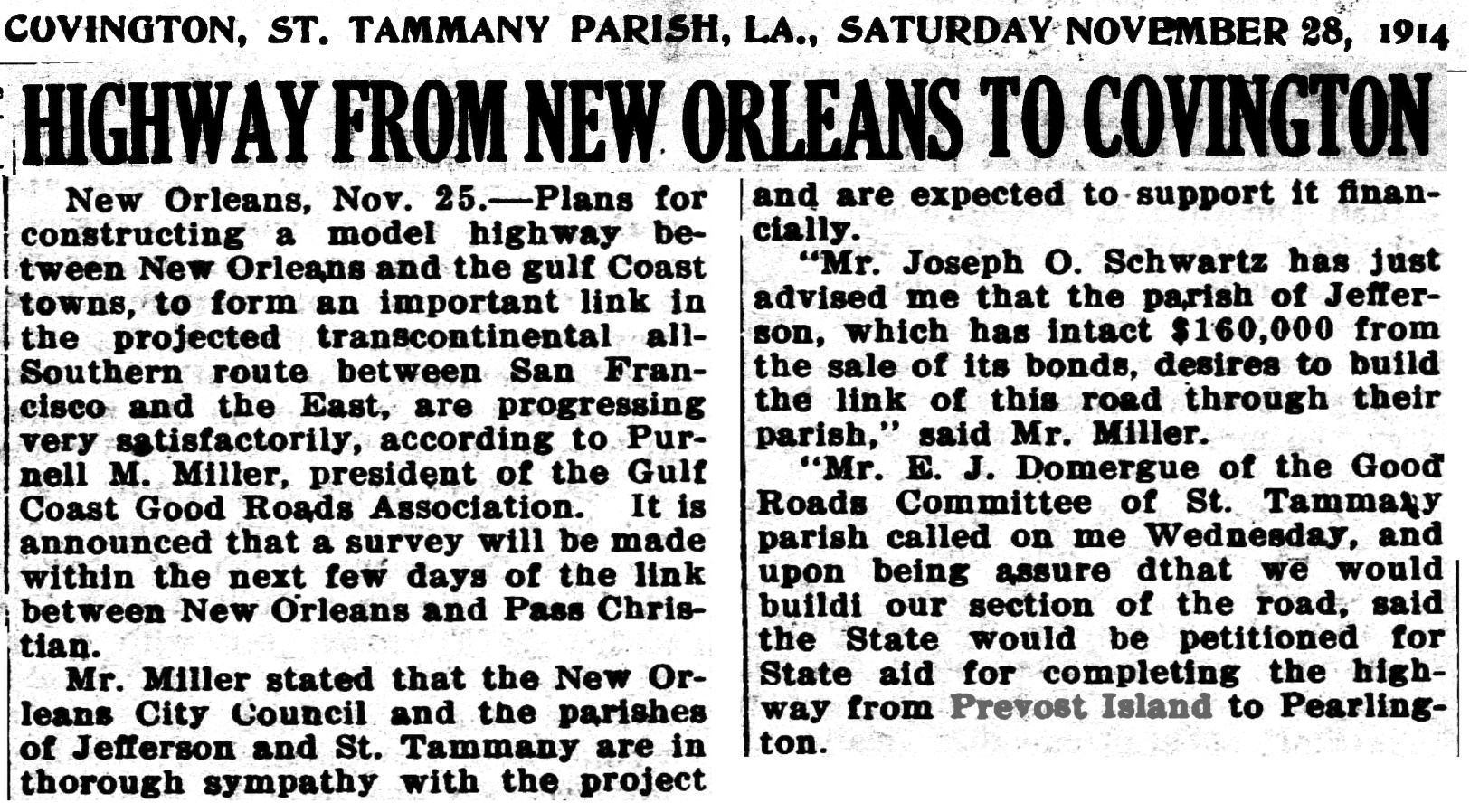
In 1886 a reporter for The New Orleans Picayune newspaper took a train ride from New Orleans to Slidell, then on to Pearl River Junction, where he switched trains and headed towards Florenville, a town that used to straddle Hwy. 36 just west of Hickory.
From there he headed for Abita Springs, tracing the route of the present day La. Hwy. 36. He recorded his thoughts, his observations, and his astonishment at the progress of the railroad and logging industry.

NEW ORLEANS TO ABITA
The Picayune August 11 , 1886
A Trip Through the Piney Woods Over the
Poitevent & Favre East Louisiana Railroad.
An Enterprise of Great Interest to This City.
Scenes in a Splendid Timber Country
The Home of the Southern Yellow Pine
On Saturday a representative of the Picayune availed himself of an opportunity to take a trip up the Northeastern Railroad to Pearl River, which is becoming a very popular resort for excursionists from this city. The fact that this run of thirty-rive miles is one of the pleasantest to be found in the neighborhood of New Orleans, seems to be fully realized by the public, judging from the large and increasing number of people who go out on the excursion trains every Sunday and spend some hours in the lovely woods of St. Tammany.
Although this railroad has been in operation for several years, there are many residents of the city to whom the route is unfamiliar. From the depot in the Third District, the track runs directly to Lake Pontchartrain along the embankment of the lower drainage canal, which is bordered by a luxuriant growth as dense as a tropical jungle. The spectator naturally wonders whether some day this rank vegetation will be cleared away, and the fertile land drained and prepared tor human habitation and agricultural purposes.
As we pass through this unreclaimed wilderness a passenger experienced in such work, remarked that it was not only practicable, but could be accomplished at an expense far below the popular estimate. In a few minutes we come within sight of the broad expanse of the lake whose waters, ruffled by the breeze, sparkle in the bright light of the morning sun.
Train Trestle
The train has now rolled out on the trestlework along the shore. Over twenty-one miles In length, it is probably the most expensive continuous structure of the kind to this country, For some thirteen miles we ran along a level, smooth track with the lake on the left and on the right hand the boundless marsh. Then, at Pointe-aux-Herbes, the train leaves the land and glides across the great bridge nearly five miles in length.
Far out on the lake flotillas of schooners, with all sails set and filled by the stiff breeze, are holding their course tor the Rigolets Pass which is barely visible as a gap in tne faint line of the eastern horizon.
First View Of St. Tammany
A thin border of glittering white sand and shells margins the green rim of the northern shore, whence stretches away to the dark woods a broad prairie overgrown with sedge and tall grasses. Here and there are pools of water that glow in the sun like mirrors of burnished metal, where herds of fat red cattle are standing up to their knees among the pond lilies. Snow white herons, flocks of chattering rice birds, and occasionally a lazy rail, startled by the whistle of the locomotive, wing their flight leisurely over the marsh.
A few minutes later and the train enters the shadowy pine barrens, and the whistle signals the first station of importance on the road, Slidell, twenty-eight miles distant from New Orleans. Seven miles further on, and we reach Pearl River Station, thirty-live miles from the city. The run has occupied a little less than an hour and a quarter. Here the reporter leaves the train. On the way up he has met Capt. John Poitevent, of the firm of Poitevent & Favre, and accepted an invitation to make a trip over the P & F, East Louisiana Railroad.
It is at this point that a branch of the East Louisiana Railroad connects with the Northeastern track. Originally a narrow gauge line, it was changed several months ago to standard gauge to conform with the Northeastern Road.

Click on the image above to make it larger.
Pearl River Station
While awaiting the departure of the Florenville train, the reporter had an opportunity to look about him and inspect the improvements which are being made. This station being the junction of the two roads and a resort for excursionists, it was determined to erect a large and commodious depot or station-house, which is now in course of construction.
Its dimensions will be 40 by 140 feet. The work is being done jointly by the railroads interested. A short distance from the track is a spacious dancing pavilion, erected by Mr. Lagroue for the accommodation of picnic parties. The words surrounding the station are thick and present a numerous variety of trees. There were standing on a side track half a dozen flat cars loaded with steel rails of the best quality, which are to be laid on the East Louisiana Railroad.
The reporter had scarcely completed his observations when the peculiar sound of whistle of the kind used on the Lake Shore Railroad announced that the train was ready to move. It consisted of a long line of eight-wheeled trucks manufactured by the Wheeling Foundry Company of Detroit, and specially adapted to the transportation of logs.
The Logging Train
They were drawn by a powerful locomotive, the "Pearl River," made by H. K. Porter & Co., of Pittsburg. Capt. Sam R. Poitevent, the energetic superintendent of the East Louisiana Railroad, was in charge, with Mr. Farrell, an experienced engineer, in the cab. The train had just dropped a load of trees into the river at the terminus of the main line, and had run up on the branch to the station. The route of the railroad is almost due east and west.

For a mile or two it leads through a thick hummock of oak, gum, ash, poplar, cypress and other trees common to the river bottoms. A large spring of excellent drinking water is passed. Springs and wells abound throughout the entire region.
Trees, Stumps and Logs
Very soon we were rolling over the line track at a rate of twenty miles an hour through the pine forest. The array of stumps which line the road indicated that the ax and saw had been busy in this section. Many large trees have disappeared from the vicinity of the route, and further off the density of the forest seems scarcely to have been broken. Laborers were observed along the, roadbed, placing telegraph poles in position. Fourteen miles of wire is aiready on the ground.
Six miles from the river, the train stops at Florenville, a village of from 250 to 300 inhabitants which has sprung up in the midst of the pine woods. It is named after a Frenchman, a large buyer of lumber, who paid a visit to the place several years ago. The principal buildings are a two-story hotel and a store belonging to Poitevent & Favre and the residences of Capt. Sam Poitevent and Mr. Josey Fevre. An artesian well is one of the improvements in course of completion.
Alter a short stay at Florenville the train goes out seven miles to the end of the road for a load of logs. En route we pass five immense barns, or stables, where the stock belonging to the railroad company is housed and fed. The necessity for such extensive accommodations for cattle is shown by the fact that the company has in service about fifty teams, which average five yoke of oxen per team, beside a large number of mules.
Through spaces in the woods, on each side of the road, could be seen a score of these teams hauling logs to the "ramps " or platforms at intervals along the track. From the ramps the logs are easily rolled off skids on to the trucks as they move up in succession.

Two miles from Florenville a spur track runs southwest for three miles and penetrates a magnificent timber forest, where gigantic pines and fine cypress trees are numerous. Continuing on the main line the road traverses a cypress belt. It is there that the cypress ties are being cut that Poitevent & Favre are shipping by the thousand through J. J. Fallon. of New Orleans to a Central American railroad company.
As the train approached the present extremity or the road the timber appeared denser, and finally a virgin forest was reached, which is still untouched by the ax. An almost unbroken silence reigns in these woods. Except when the ax men and sawyers are at work, the only sound to be heard is tne soughing of the wind in the pine tops.
This is the Choctaw land. The graves of their people are scattered through the woods, and off to the south is the settlement where linger the last of the race. Nine miles to the southwest is Mandeville; seven miles due west are the Abita Springs, and two miles beyond and almost in the same straight line is Covington on the Tchefuncta.
Covington
The latter town is the objective point of the East Louisiana Railroad, towards which it will be pushed rapidly as soon as the busy summer months are passed. There are no obstacles in the way, the ground is level and firm, and ties are plentiful. By the time the writer had made an excursion to "Generelly Station," half a mile from the end of the road, the train had been loaded with its burden of logs which were rolled upon the trucks from the ramps. There were four or five logs to a truck.
Some idea of their size may be formed from the statement that one tree was estimated to weigh 10,000 pounds, being a spar 86 feet long and 18 inches at the top. It Is no unusual thing to haul 225 trees per day on the railroad. Last month the timber transported aggregated 1,500,000, and with good weather, the amount for August will foot up 2,000,000 feet.
Train Trucks Filled With Logs
The "Pearl River," drawing the immense train of logs steamed off to the eastward at the rate of from 15 to 20 miles an hour, This speed is rendered practicable by the excellent condition of the roadbed. which requires very little ballasting: the ties are placed close together and are well laid. The road leads directly to the bank of Pearl River, and the trucks line up with a chute or sloping framework of legs very strongly constructed.
The process of unloading was very interesting. The logs once started from the trucks rolled down the inclined and dived into the river, raising a great commotion in the water and sending the spray high up into the air. The stream at that point is from twenty to thirty feed deep, and runs with a four mile current at high-water stage.
The logs, each bearing the owner's mark, float down the river for thirty five miles, and are arrested in their voyage at Pearlington, where the Poitevent & Favre Mill is situated. There they are converted into lumber of various kinds, at the rate of about 120,000 feet per day, and go out in this new form on the vessels of the company and foreign ships to the Gulf ports, Europe and other parts of the world.
Nearly 300 men are employed on the East Louisiana Railroad. The total length of track, including branches and switches, is about seventeen miles. The road is in excellent condition, fully equipped and in first class running order. The Poitevent & Favre tract of land, comprising some 75,000 acres, is bisected by the railroad, the sections on each side having an average width of about six miles.
By next spring the line will have been finished to Abita Springs and Covington.
President Galt, of the Queen and Crescent Railroad, (The Northeastern) is anxious to have the road completed to Abita Springs, which, he thinks, will attract many visitors from the North and West. He will make special rates over his road from Cincinatti and other Western cities. The trip from New Orleans to Abita by the Northeastern Railroad and East Louisiana Railroad will occupy less than two hours' time. It will be an easy matter for the residents of this city to visit daily the healthful pine woods of St. Tammany and profit by the medicinal and sanitary properties of the springs.
Railway connection between Abita and New Orleans, which has so often been discussed as a possibility of the future, is soon to be a fact, a reality.
End of article

The Oak Downs quarter horse race track in Pearl River was a popular destination back 30 to 50 years ago.
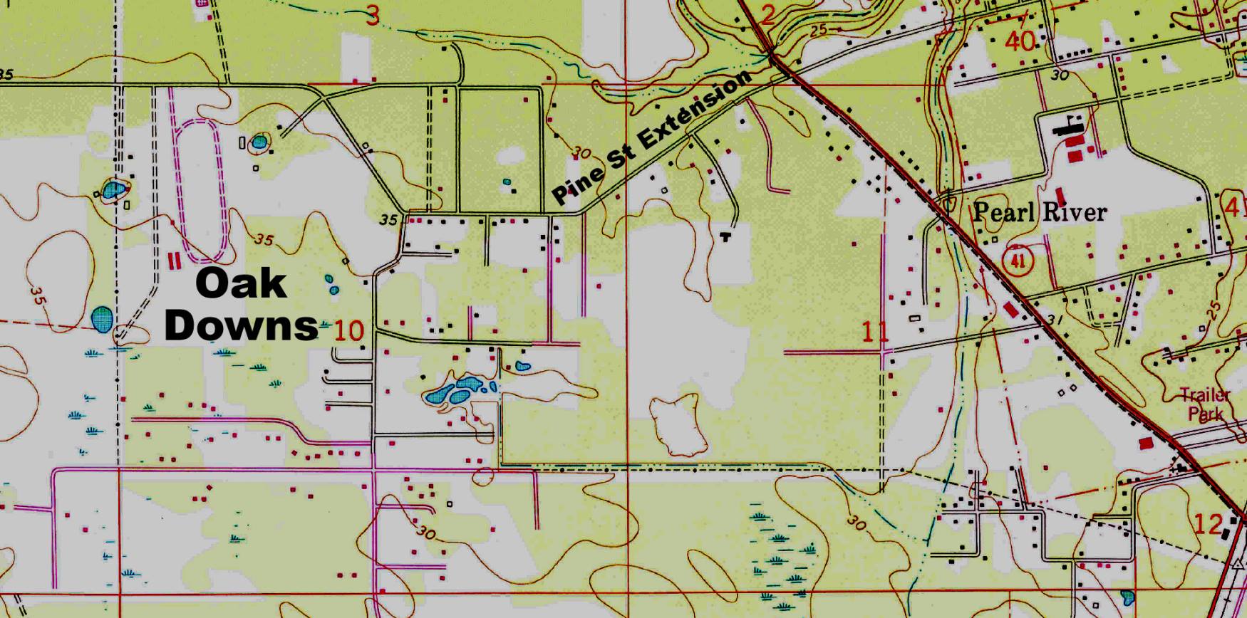
According to local residents commenting on Facebook, the Pearl River quarter horse race track was located east of Oak Downs Drive. It was owned by Eddie Holdsworth, they said, and several remembered going out there when they were kids.
"My dad use to race horses out there before I was born. He took me a lot when I was a kid to watch the races," one person said. Lee Williams remembered having quick snippets of video of his dad and grandfather at a race there.
"Up until about 20 years ago and many years after they had stopped using it as an actual racing track, but they used the barn/stalls in the far back, right corner of the property (just beyond where the grand stands used to be). Those who still owned horses locally but would race them in other areas (New Orleans, Lafayette, etc) would rent the stalls out for their horses. The horse owners would have their trainers come there and they would still use the track to train and time the horses. I went there ALOT with my dad growing up. I think that they were still using it in that capacity by the time that I graduated high school in 1994."


Another commenter said that Claude Polk and brother Jake raced a quarter horse named Bar Queens there.
"It was a great way to spend a Sunday afternoon," said Allen Decker. " They held one of the Pearl River Catfish Festivals there."
Twyla Beals said that she loved going there. "My Grandfather (Chuck Craddock) and his brother Rick had a horse (Parkers Warrior) this was in the early 70's. I was little but still remember it all!"
Here is a photograph, taken in 1908 , of the Ludwig Koenig Family, who ran a sawmill in Pearl River.

This picture, taken in 2011, shows the 1986 football team from Pearl River High, back on the field for a visit in uniform.


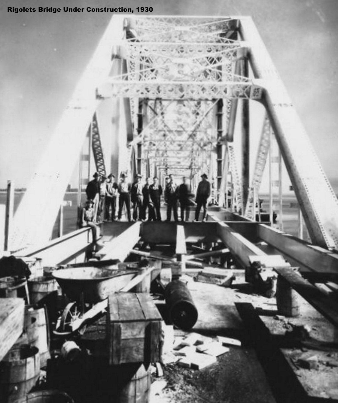
After years of steamboats carrying passengers (and automobiles) across Lake Pontchartrain from New Orleans to Mandeville, the dream of building a road around the eastern end of the lake began to materialize.
In 1918, serious efforts were initiated to build a road from Chef Menteur and New Orleans, towards the southeastern portion of St. Tammany Parish. An editorial in the St. Tammany Farmer newspaper of May 11, 1918, stated the following:
The Chef Menteur Road
When St. Tammany does it part, the road from Chef Menteur to Slidell will unite this parish to the New Orleans to the Gulf Coast road, which will give us excellent connections with other points, and the building or the road to Hammond will still further give us good roads connection.
Under the provision of the legislature automobile licenses will be turned into tho Stale road fund and will assist greatly in the construction of roads to which this parish will have access. Survey of the road from the Rigolets to Slidell and from Slidell lo East Pearl River at a point in Mississippi between Napoleon and Logtown is already completed and an approximate cost furnished.