Thursday, February 15, 2024

Forgotten Tammany Towns

 St. Tammany Parish over the years has been home to many communities, some of which appeared on early maps but are no longer listed on modern maps. A number of those have been forgotten by current residents, except perhaps the families of the earliest pioneers who settled the area. 

An early United States Post Office Placename Database however, lists many of those no longer placed on maps. 

The map below was distributed by the St. Tammany Chamber of Commerce in 1930.


Here are a couple of maps from the 1910's and 1930's.


Click on the above image to make it lager. 

In the maps of St. Tammany Parish from the 1910's and 1930's, we find the following:

Alma (just west of Folsom)

Onvil (just south of Folsom)

Ramsay (north of Covington)

Galloway (north central St. Tammany)

Violin (east of Talisheek)

Houltonville (east of Madisonville)

Florenville (northwest of Pearl River)

Maud (northwest of Slidell)

Honey Island (northeast of Pearl River)

Starlding (southeast of Slidell)

Bradley (west of Covington)

Hygeia (west of Slidell) and 

Nott (Fontainebleau Park)

Dave (between Talisheek and Bush)

Wortham (south of Talisheek)

The Pearl River swamp had several named communities: Lewis, Benton, and Mufree (all northeast of Slidell).


(Thanks to Jack Terry for providing the information referenced above.)


Old USGS Topographical Maps also listed community names no longer on modern maps. 


McClane City


Union Grove (La. Hwy 40 near Sharps Chapel)


Dave was located on the train track at the lower corner of Watts Thomas Road, Bush.


See also these links:


Monday, February 12, 2024

Krewe of Bogue Falaya Welcomes Grand Marshal

 The Krewe of Bogue Falaya revived an old Carnival tradition in Covington Monday, with the Grand Marshal arriving by boat coming up the Bogue Falaya River to great fanfare.

Krewe Parade Captain Larry Rolling met Grand Marshal Grayhawk Perkins at the Bogue Falaya Park boat launch, welcoming him to the city and presenting him with a special official sash. Then the crowd of over 200 people joined him in a festive second-line procession up New Hampshire Street to the Southern Hotel where refreshments and king cake were served. The group was accompanied by live music and the dancing Lollipops. 

The special Lundi Gras event was a revival of a previous tradition where parade royalty were brought up by boat and docked at the Columbia Street wharf. 

Here are some pictures of the today's newly-minted event, 2024 style. Click on the images to make them larger. 


Grand Marshal Grayhawk Perkins


Large crowd waiting for the boat to arrive. 


The special guest slowly advances up to the dock. 


He is greeted by a cheering crowd.


And the band played rousing Mardi Gras music


(Photos by Ron Barthet)


Local news media were on the scene to record his first words.


Parade Captain Larry Rolling welcomes Grand Marshal Perkins


He receives his special sash. 


He is officially invited to lead the procession to the Southern Hotel. In the first decades of the 20th century, over 100 years ago, the Southern Hotel played a key part in area Mardi Gras celebrations.


Let the music play and the special second-line procession begin.


Led by a "Lundi Gras" banner.


Hundreds of people took part in the celebration


The crowd gathers at the entrance of the Southern Hotel for greetings by Parish President Mike Cooper and a proclamation by Covington Mayor Mark Johnson


Mike Cooper toasts the Grand Marshal


Mayor Johnson, at left, prepares to read the proclamation


The official sash


Many families turned out for the special occasion


Mayor Mark Johnson was on hand at the boat's arrival.
He's at left with Jimmy Nelson at right.

Here's a video of the day's activities.
------------------------------------


Over 100 years ago, this was the scene when Carnival royalty arrived at the Columbia Street Landing in Covington. The Bogue Falaya River was dredged to accommodate larger boats back in those days.


See also these links:

Saturday, February 10, 2024

Theodore Dendinger Cemetery

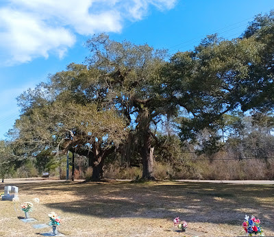
 In the late 1950's a new cemetery was established off La. 21 north of Madisonville. It became the Theodore Dendinger Sr. Memorial Cemetery. The five acres of land was formally donated in 1962 and has been in use ever since. 


At the front of the cemetery are three massive oak trees. 

Click on the images to make them larger. 


In 1979 the Madisonville highway alongside the cemetery was widened, prompting numerous local preservationists to keep an eye on the trees, wary of what had happened during a state highway widening project in Mandeville. That was where the "Chinchuba Oaks" were secretly cut down one Mardi Gras. Next Tuesday is the 46th year anniversary of that  eye-opening event.

Here are some recent photographs of the oaks in front of Dendinger Cemetery. 


See also these links:

The Chinchuba Oaks and Mardi Gras Day

The Oak Trees of 21st Avenue 

Trees Green Up For Spring 

A Monumental Oak Tree 

City Hall Oak Tree 

Post Oak 

Seven Sisters Oak - 1982 Cover Tree 

Vintage Court 

Live Oak Trees Recognized 

Lakeshore Drive Tree 

The Tree on the Wall 

St. Tammany Loves Oak Trees

Tree Branch Avalanche

Monday, February 5, 2024

Florenville Wants A Post Office - 1888

 The Florenville Post Office was applied for in 1888, with the proposed location being pinpointed in an application to the U.S. Postmaster General. Here is some information from that application. 

This article is a follow up post to a previous blog that detailed a train trip from New Orleans to Abita Springs, through Slidell, Pearl River, and Florenville. Link to previous blog article. 

Application for a Post Office at Florenville, LA

Dated: May 18, 1888

The application required that the information being submitted be verified by the postmaster of a nearby established post office.

The name of the person making the application was J. Poitevent, with the Postmaster of Pearl River forwarding the application document to Poitevent. The Pearl River area post office was named Hallo at that time, and Emily J. Welsh was identified as the postmaster of that facility. 

The Florenville post office was to be located in the northeast quarter of Section 30, Township Seven South of Range 14 East. It was to be along the existing mail route between New Orleans and Covington "on which the mail is now carried seven times a week."

The contractor of the post office was identified as the East Louisiana Rail Road Company, and it was said to be located inside the railroad station building, thus the railroad station was the location of the proposed post office. 

The new Florenville Post Office was located about five miles west of Hallo. It was also fifteen miles east of the next post office on the route, that being Abita Springs. The application even mentions the nearest river (Pearl River), and the nearest creek (Gum Creek).

The application also noted that the proposed Florenville station was about ten miles to the nearest "flag station," that being called "Mandeville Junction," the location of a spur line that left the main track that ran between Florenville and Abita Springs, and angled southwestwardly to go down to Mandeville. A flag station was a station at which trains stopped only if signaled to do so.

The main track followed the path of today's La. Hwy. 36, and the Mandeville Junction spur followed the path of today's La. Hwy. 1088.

At the time of the post office application there were 200 people living in Florenville, and John A. Orr was suggested as the Postmaster for the proposed Florenville post office.  

Abita Springs began growing by leaps and bounds when the first train of the East Louisiana Railroad, built by Poitevent and Favre, arrived on June 26, 1887.The train track was extended to Covington the following year. Overnight excursions from Covington to Abita became popular with the extension of the railroad to Covington.


Click on the image to make it larger. 

A map of postal routes in St. Tammany in 1895. The mail was carried by train from New Orleans along the New Orleans & Northeastern Railroad Line past Slidell and up to Pearl River Junction, which in 1888 was named Hallo. From there it transferred to another train which took it to Florenville, past Mandeville Junction and then on to Abita Springs and Covington. The Talisheek post office was somewhere near Waldheim for some reason.

Folsom had not been established yet in 1895, but mail was being delivered to the "Verger" post office which was just south of where Folsom would be. Verger was about one and one-third miles south of Folsom. Paul Verger, born in 1858, was post­master at Verger. His father had come to St. Tammany by way of New Orleans and Switzerland. By presidential proclamation, Paul Verger was made postmaster in 1892


A map showing the location of the proposed post office.


The application form filled out by Poitevent asking for the Florenville post office. 

(Thanks to Jack Terry for supplying the above information.)

See also: