Wednesday, May 31, 2017

Mandeville Building Maps 1904

One of the best resources for historical researchers are the Sanborn Fire Insurance Maps of the early 1900's. The maps were made to help insurance companies assess fire risk associated with various buildings. Different colors were used to denote different types of construction, and some of the buildings were marked indicating their names and uses.

Here are the lakefront area Sanborn Maps for Mandeville in the year 1904. The street named Clayborne is the same as the street spelled Claiborne today. Click on the images to make them appear larger. 


Above is the lake area Sanborn map for Mandeville in 1904, spanning the blocks between Coffee and Lafitte. Lake Pontchartrain is at the bottom. On the lake just west of Coffee St., near where the drainage canal is currently located, was the Lake View Hotel. Behind the hotel, half a block up on the west side of Carroll was a "Lodge Room" building. All of the buildings that are yellow are "wood frame" buildings.


Above is another Sanborn map of the lake area in 1904, this map spanning the blocks between Lafitte St. and just east of Girod St. Lake Pontchartrain is again at the bottom. There is a General Store on the southwest corner of the Clayborne and Lafitte Street intersection. Click on the image to make it appear larger. 

Down at the lakefront, there is a drug store on the lake just west of Lafitte Street. The drug store is on the east side of a building that looks like another hotel. Across Lafitte Street on the east side, also on the lake, is Mugnier's Hotel. Next to that is a "casino," which was probably the old Bechac's Restaurant building. On the west side of the Girod St. and Lake St. intersection is a building labeled "Grocery" and on the east side of Girod is a building marked "Vac." It is currently the location of "Don'z on the Lake" Bar. It is shown with the color red, which indicates it was a brick building, while the rest of the structures are yellow, indicating they were wood frame structures. 


The map above shows the buildings in the area of the intersection of Clayborne and Carroll Streets in 1904. At the top left is the Post Office (P.O.), and across the street from that is the Presbyterian Church (which is still in the same location today). 

In the southeast quadrant of the intersection is a General Store. Across Clayborne Street from there is a frame building marked "Vac" which could stand for vacant. These maps were downloaded from the Library of Congress Historical Maps website. 

To view the maps from the year 1909, CLICK HERE.

Tuesday, May 30, 2017

Armoire on Lee Lane

Below is a photo of the Armoire shop on Lee Lane in the 1980's, processed through a watercolor filter. Click on the image for a larger view. 


Kiwanis Club Meeting

The Covington Kiwanis Club has been engaged in a number of community improvement projects, Key Clubs, and many other civic activities for years. This morning I attended their meeting at the Covington Presbyterian Church Fellowship Hall and took a picture of their new officers. Click on the images to make them larger.


They are, from left to right, Dan Johnson, President, Diane Brehm, Vice President, Irvin Breaux, Immediate Past President, Kelly Fern and Billy Warr, Treasurers, and Dorothy Garcia, Secretary. 


They asked me to speak briefly about what I do, so I told them about being interested in preserving history using my internet blog, old photographs, cartoon maps, and the stories of the many people I interviewed over 30 years in the news media. 


Lacombe Area Recollections

About 47 years ago, Hilda D. Streck wrote a delightful account of life in the Lacombe area in the early and mid 1900's. The story included highlights from her childhood, with information about fishing, gigging, schooling, and trips to Slidell in its early days. The memory of her first hurricane is especially interesting. 

There are a lot of people named, stores mentioned, and progress made as Lacombe grew into a larger and larger community. 

There are four pages. Click on the images below to make them larger and more readable. If you would like to download a PDF file of the booklet, CLICK HERE.


Page One


Page Two


Page Three


Page Four

See also: Lacombe Topo Map of 1935

Monday, May 29, 2017

Mandeville Harbor Scenes

Photographs and art filtered pictures from the Mandeville lakefront harbor. Click on the images to make them larger. 


Sunday, May 28, 2017

St. Tammany In The Early 1900's

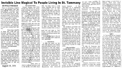
Big changes were on the way for St. Tammany Parish in the first half of the 1900's. A snapshot of life at that time was provided by newspaper feature writer Polly Morris in a 1976 article she based on information from a 1954 booklet. It contained statistics from previous years and presented, as she termed it, a clear picture of the "invisible line" that separated the City of New Orleans from the rural landscape of St. Tammany. The changes in St. Tammany from 1900 to 1954 she discussed 41 years ago are even more interesting looking back now from 2017.


Click on the image to make the article larger and more readable. 


Madisonville Night Boat Parade Photo

This is a photograph, taken many years ago, of the Madisonville New Year's Eve boat parade, processed through an oil painting filter. The boats are decorated with lights, a slight fog has rolled in, and people are awaiting the midnight fireworks. 

Click on the image to enlarge the view. 


See Also: Night Boat Parade Photos

Saturday, May 27, 2017

Suella's

This article about Mrs. Ella Hadley and her Suella's Inc. shop appeared in a 1972 edition of Pathways Magazine. 

Click on the images below to make them larger and more readable.


For a while, Suella's was located in the Bogue Falaya Plaza shopping plaza


Below is a feature article from a 1972 Pathways Magazine:


The first Suella location at the corner of Columbia and Lockwood Streets

The current Suella's location is on Hwy. 21 south of Covington near the First Baptist Church. CLICK HERE for more information on that new store.


Friday, May 26, 2017

Car Show and Block Party May 2017

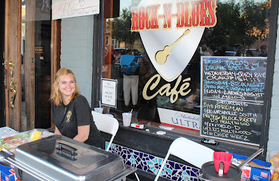
Downtown Covington was the location for the May 26, 2017, Final Friday Block Party and Car Show, with dozens of cars lining Columbia Street and hundreds of people visiting with each other, viewing the cars, and enjoying the cool Spring weather. 

Here are some pictures.


The Marianne Angeli Rodriguez Studio Gallery was open for visitors. It is now located at 323 N. Columbia Street


The St. Tammany Art Association drew crowds


The Covington Kiwanis Club was on hand dishing out sandwiches and refreshments


Doree Kelly with the Northshore Enduring Hope Foster Family Support Group was selling lemonade.