
A block later it became Kemper street, a two block stretch that is the first cross street when one enters Covington from the east.
Lee Ferry Road eventually became known as Lee Road, and Kemper Street became known as Lee Lane, home to a number of quaint shopping venues.Many legal property descriptions still refer to Lee Road as Lee Ferry Road.
Lee Ferry Road is named in honor of the ferry which helped travelers get across the wide Bogue Chitto River, not General Robert E. Lee as some had come to believe.
Here are some maps.

Lee Ferry Crossing on the Bogue Chitto River north of Covington

The Covington Sanborn Map of 1909 shows Lee Ferry Road coming into town

Lee Ferry Road became Kemper Street (as shown in this 1934 map)

And Kemper Street became Lee Lane

Google Earth aerial photo of Lee Ferry location

Here's a trace in red of Lee Road from Covington to Hwy. 439 in Washington Parish as labelled by Google Maps. Many land ownership maps and records still refer to Lee Road as "Lee Ferry Road."

In the 1936 aerial photo below, Lee Ferry Road is seen angling off to the northeast.
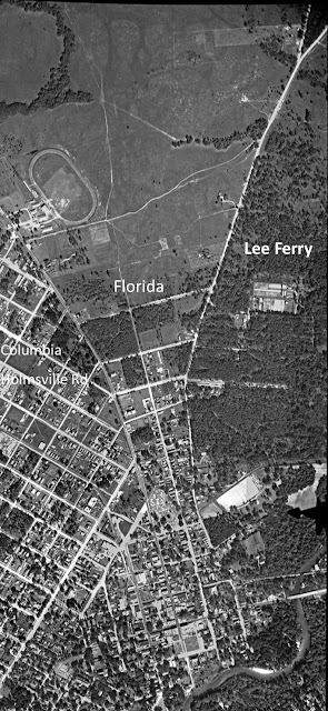
In the upper left is the race track at the parish fairgrounds. In the lower right is the Bogue Falaya River, the Boston Street bridge, the railroad bridge, and at the bottom is Charropin Beach.
See also: