No river has played a greater part in the development and expansion of America than the Mississippi. Since the first white man viewed this mighty stream, it has been a vital factor in the physical and economic growth of this country.
It has stood in the path of discoverers, challenging their ingenuity to cross it. It has fired the imaginations of explorers, luring them on to seek out its mysteries. And always it has stood in the minds of practical men as the key to westward expansion, an economic prize to be sought and held at all cost. As such, it has been fought over on the battlefield and used as a pawn in diplomatic exchanges.
Coursing in a buttonhook pattern out of tiny Lake Itasca in northern Minnesota, it twists and turns through the land of the Chippewa, 2,340 miles south through the heart of the United States. It sweeps past Minneapolis and St. Paul, growing larger as tributaries add their flows, past St. Louis, where the Missouri joins it, past Cairo to receive the waters of the Ohio.
Here it becomes the lower Mississippi, a river giant, unequaled among American waters. Flowing south, it touches romantic river towns—Memphis, Greenville, Vicksburg, Natchez, Baton Rouge, and New Orleans. Almost a thousand river miles south of Cairo, it pours its torrent into the Gulf of Mexico.
DISCOVERY
Columbus may have been the first white man to view the Mississippi River. An "Admiral's Map" in the Royal Library at Madrid, said to have been engraved in 1507, shows the mouth of the river, then called "The River of Palms." But this is conjecture.
In 1541, Hernando DeSoto did view the Mississippi at a point near or just below Memphis, Tenn. DeSoto died in April 1542, but his followers continued the explorations. The historian of the expedition, Garciliaso de la Vega, described the Mississippi as in a flood of great severity and of prolonged duration, beginning about the 10th of March in 1543 and reaching its peak about 40 days later. The flooded areas were described as extending for 20 leagues on each side of the river.
One hundred and twenty years later, Joliet and Marquette explored the river, traveling from its upper reaches to a point near Arkansas City, Ark. Soon after, LaSalle descended the greater portion of its length to its mouth. In 1699, d'lberville entered the mouth of the river and at a point near Old River received a letter from an Indian chief previously left there by LaSalle.
EARLY NAVIGATION
Within a few years, French traders had settled along the Mississippi River and had penetrated the territory of the Natchez Indians.
In 1705, the first cargo was floated down the river from the Indian country around the Wabash, now the States of Indiana and Ohio. This was a load of 15,000 bear and deer hides brought downstream and out through Bayou Manchac, just below Baton Rouge, and Amite River, then through Lake Maurepas and Lake Pontchartrain to Biloxi, with final destination in France. This route is not now open, Bayou Manchac having been closed with construction of the Mississippi River levee system.
Fort Rosalie, the first permanent white settlement on the Mississippi River and now called Natchez, was built by the French in 1716. Bienville founded New Orleans in 1718, and four years later this city was made the capital of the region known as Louisiana.
The rapid growth of New Orleans, in its early days and even now, was due principally to its position near the mouth of the river. Navigation grew and developed with the settlement of the lower Mississippi Valley.
RAFTS
The canoes of the Indians soon proved inadequate for the needs of the settlers. The flatboats and rafts which succeeded them were one-way craft only. Loaded at an upstream point, they were floated downriver and their cargoes were unloaded, then they were dismantled and sold for lumber. Built for one trip only, they were cheap and often poorly constructed, but carried large quantities of merchandise at a time when transportation was vital to the growing valley.
KEELBOATS
The keelboat was the first queen of the river trade. A two-way traveler, it was long and narrow with graceful lines, built to survive many trips. A keelboat could carry as much as 80 tons of freight. Floated downriver, it was "cordelled" up the stream. This called for a crew of tough and hardy men, for cordelling was a process by which a crew on the bank towed the keelboat along against the current.
STEAMBOAT NAVIGATION
Invention of the steamboat in the early nineteenth century brought about a revolution in river commerce. The first steamboat to travel the Mississippi was the New Orleans. Built in Pittsburgh in 1811 at the cost of $40,000, she was a side-wheeler 116 feet long and 371 tons. She was taken to New Orleans by Nicholas Roosevelt, a relative of the Presidents.
On her maiden voyage, the New Orleans was caught in a series of tremors known as the "New Madrid Earthquake," probably the worst non-volcanic earth shock in American history. Nevertheless, she continued downriver on a nightmarish trip to become the first steamboat to travel the Mississippi, arriving in New Orleans January 12, 1812. She was then placed in service between New Orleans and Natchez. Two years later she hit a stump and sank.
The Resourceful Captain Shreve
In December 1814, Captain Henry M. Shreve brought a cargo of supplies for General Andrew Jackson's army from Pittsburgh to New Orleans in his side-wheeler, the Enterprise. He climaxed his trip by running the British batteries below New Orleans to deliver military supplies to Fort St. Philip.
(While Robert Fulton is usually given credit for development of western steamboats, Captain Shreve worked out structural and mechanical modifications without which the steamboat would have been useless in the west. Shreve was also instrumental in breaking the monopoly of Fulton on the Mississippi.)
Although steamboats were in service between New Orleans and Natchez, they had not yet traveled far upriver. Captain Shreve met this challenge with his Washington, built in 1816 at Wheeling, W. Va. It had a flat, shallow hull and a high-pressure engine.
In 1817, the Washington made the round trip from Louisville to New Orleans and return in 41 days. The golden era of the paddle-wheeler had begun. Where in 1814 only 21 steamboats arrived in New Orleans, in 1819 there were 191; in 1833 more than 1,200 steamboat cargoes were unloaded.
STEAMBOAT OPERATIONS
Some steamboats were operating on the Mississippi and Ohio, mostly between New Orleans and Louisville. In 1817 there were 14; in 1819, 31. But the appearance of the steamboat on the Mississippi River above the mouth of the Ohio was delayed for several years.
In August of 1817, the ZebuIon M. Pike made the trip up the river to St. Louis. Three years later, the Western Engineer made a trip from St. Louis up the Missouri River and later a part of the way up the Mississippi above St. Louis. In April 1823, the Virginia left St. Louis bound for scattered posts up the Mississippi. Twenty days and 683 miles later, the Virginia docked at Fort Snelling, Minn., at the confluence of the Minnesota and Mississippi Rivers, the first steamboat to make this trip.
By 1830, the steamboat age had come to the upper Mississippi, and by 1840, there was heavy river commerce between St. Louis and the head of navigation at St. Anthony's Falls (vicinity of St. Paul).
Not only could the steamboat haul freight, but it had comfortable accommodations for passengers. Even more important, it could travel upstream almost as easily as it traveled downstream. In the period preceding the War Between the States, its decks carried cotton and other produce to market; it brought back the staples and the fineries available only from outside the region; and it brought visitors from afar and furnished transportation to other sections of the country.
Steamboat travel was hazardous and irregular in the early years. Although it furnished faster, more dependable, and more useful transportation, it left much to be desired during its early period of development.
Before the invention of the steamboat, a trip from Louisville to New Orleans often required 4 months. In 1820, the trip was made by steamboat in 20 days. By 1838, the same trip was being made in 6 days.
In 1814, the Orleans made the 268-mile trip from New Orleans to Natchez in 6 days 6 hours 40 minutes. In 1880, the Robert E. Lee made the trip in 17 hours 11 minutes.
These boats were by no means small by Mississippi River standards. The Lee was 300 ft long and 1,467 tons, while the Natchez was 301.5 ft long and 1,547 tons. They were both longer then the Sprague, the largest paddle-wheel towboat ever built, and one had greater tonnage.


PACKET BOATS
The packet boat brought a phenomenal increase in traffic. In 1834, there were 230 packets; by 1849, there were about 1,000, approximating a total of 250,000 tons. The packet continued to be the principal means of transportation in the Mississippi River Valley until the latter part of the nineteenth century; then, more and more of the commerce began to be diverted to the expanding railroads. River commerce seemed to have died almost completely.
In 1907, the Sprague set a world's all-time record for towing 60 barges of coal, weighing 67,307 tons, covering an area of 6-1/2 acres, and measuring 925 feet by 312 feet.
The St Louis arrived in New Orleans in 1931 with 28,200 bales of cotton on eight barges and three other barges of grain and merchandise. This is supposed to be the largest cotton tow that ever traveled the Mississippi River.
The retirement in 1961 of the U. S. Army Engineers Steamer Mississippi, last of the Texas-deck stern-wheel towboats operating on the lower Mississippi River, brought the steamboat era closer to an end, giving way to the modern, diesel-driven vessels with greater towing power.
That same year the Motor Vessel Austin S Cargill pushed a record tow of grain to Baton Rouge-42,200 tons in 36 covered barges, 210 feet wide with an overall length, including the towboat, of 1,352 feet.
RECREATIONAL BOATING
Boating is a popular form of recreation on the Mississippi. There are several paddle-wheel passenger boats operating on the river. They provide cruises reminiscent of those of the nineteenth century riverboat days, although much shorter. These paddle-wheelers hold several races each year. Small boat navigation for recreation is growing each year. Small boat lockages now represent 26 percent of those made at Lock 25 at Winfield, Mo., for example.
RIVER COMMERCE
During World War II, Mississippi River transportation assumed an even more important role than ever before. The principal commerce on the lower Mississippi River consisted of the upstream movement of gasoline, oil, sulphur, and other products and materials vital to the war effort. In addition, 3,943 Army and Navy craft and other vessels for use in the war—destroyer escorts, fleet submarines, landing craft, freighters, tankers, and oceangoing tugs—moved from inland shipyards down the Mississippi to the sea.
Without question the Nation's principal river, the Mississippi is the main stem of a network of inland navigable waterways maintained by the U. S. Army Corps of Engineers, which form a system of about 12,350 miles in length.
Here are images of the sections of the publication that contained historical information. Click on the images to make them larger and more readable:

Page One

Page Two


The Mississippi River, when combined with its longest tributary, the Missouri River, is 3485 miles long. The Missouri River has its headwaters in Three Forks, Montana, where the Jefferson, Madison, and Gallatin Rivers unite to form one river.
On the back of the map was also detailed information on federal projects to improve navigation on the Mississippi, from work being done on the mouth of the river as it goes into the Gulf of Mexico to the levee system that lines the waterway. In addition, the map showed tonnage statistics of the various ports along the Mississippi, Missouri, Ohio, Arkansas and Red Rivers
The map was a publication of the Public Affairs Office of the Mississippi River Commission and
U.S. Army Engineer Division, Lower Mississippi Valley, U.S. Army Corps
of Engineers, out of Vicksburg, Miss.
RUMSEY's CONTRIBUTION
What connection does this have to St. Tammany Parish? In the late 1700's, several people were feverishly working on developing a steam-powered watercraft that could move upstream against the current, and one of those was St. Tammany resident James Rumsey. He did some of his early work in Lacombe and on Pearl River Island, then moved to Shepherdstown, West Virginia, to finish the work and build a working steam-propelled boat. On December 3, 1787 he demonstrated its capabilities on the Potomac River.

So Rumsey is recognized as the inventor of the steam-powered watercraft, which only a few years later led to steamboat development. Those steamboats made trade on the Mississippi River to and from New Orleans a reality.
Historian Don Sharp discovered the above information about Rumsey, and it is detailed on his blog.
 Pirogues
 The first steamboat arrives
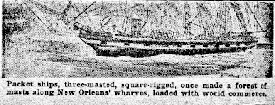 Packet ships
 The famous steamboat race

The Natchez/Robt. E. Lee Steamboat race is one of the great river legends that ignited the imaginations of all Americans of the time. It has been depicted in song, movies, and hundreds of paintings, such as the one above.
 Tugs
Tugs

Towboats and Pushboats
----------------------------

The steamboat race was a topic of conversation for many years

Towboats and Pushboats

See also: