In 1909 the trolley car that ran between the Mandeville lakefront and downtown Covington opened up for business. The trolley would roll out onto a pier that jutted out into Lake Pontchartrain, steamboats carrying passengers from New Orleans would dock, and passengers would board the trolley right at the end of the pier, then be carried back onto land and onwards to Abita Springs and Covington.
The name of the company operating the trolley was originally the St. Tammany Railway. It was later lengthened to the St. Tammany and New Orleans Railway and Ferry Co., as boats were added.
It was a great system, and hundreds of visitors would utilize the trolley car to finish their trip to the Abita Springs and Covington hotels of their choice.
Here is the original printed map of the trolley motor car route. There were actually two rail lines going from Mandeville to Covington. The trolley car route was different than the railroad track route, and they crossed over each other just west of Abita Springs. The train tracks went straight down to Mandeville from Abita Springs, swung by the Mandeville depot, then headed for Slidell.
The printed version of the trolley motor car route.
Click on the images to make them larger.
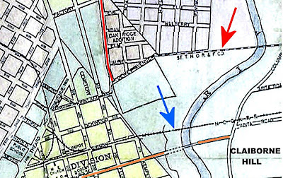
In this 1909 map, the trolley line is pointed out with a red arrow. It crosses the river upstream of Claiborne Hill, enters Covington along East Clark Street, and then goes along Dewey Avenue to Kirkland, past the cemetery and ends near where the police station is today. The blue arrow points to the railroad track bridge over the river, which is today Tammany Trace.
In this 1965 aerial photo of Covington, the path of the trolley line is clearly visible through the trees. Collins Blvd. didn't exist during the time of the trolley, so the trolley line route left Covington along East Clark Street, crossed the Bogue Falaya River and headed east towards La. 21 (Military Road). It crossed La. 21 just a little north of Melissa Lane.
In this recent aerial photo a powerline right of way shows up as a horizontal shadow extending from Collins Blvd., across the Bogue Falaya River and over to Military Road into the Garland Addition. This was likely the path of the trolley line, since in its last few years it was an electric trolley.

Since the trolley line track bridge over the Bogue Falaya river was further upstream than the railroad track, the two tracks had to cross over each other just west of Abita Springs. Old aerial photographs, the above being from 1965, still showed the path of the trolley car line as it intersected with the railroad line just south of where the Abita Brewing Co. is today.
The trolley car route was still visible as a path through the trees as late as 1978.
On its way down to Mandeville, the trolley route passed through Abita Springs and headed southward, but veered to the west between North and Soell Streets on a diagonal route to head for Helenberg subdivision and Ozone Park. Once it left there, it headed south but as it pulled into Mandeville it zigzagged back and forth from block to block until it got to the lakefront and pulled out onto the pier.
The Farmer welcomes the railway and trolley
The Original Source Map
In a stack of old documents recently found in Covington, researchers discovered the original hand-drawn map from which the above printed map was made. Here is a copy of the original trolley "motor car" route map. Some areas are shaded red, yellow or brown to indicate large property holdings along the way.
Here are four sections of the above map enlarged for detail.
Covington, Abita Springs and Alexiusville
Helenberg and Ozone Park
The trolley route is a marked by triple parallel lines from the top right
Chinchuba and Glendale Heights
Mandeville and Bayou Castin
The trolley line ends on the pier into the lake, while the train track heads southeast into Lacombe and Slidell.
Depots
On the trolley car line, there were depots at Helenberg & Ozone Park.
Helenberg was a subdivision developed by the owner of the trolley line
Spellings Differ
The
owner's name was "Joseph Birg," and on some maps the name of the
subdivision is spelled "Helenbirg" while on other documents it is
spelled "Helenberg" with an "e."
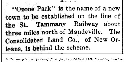
Ozone Park was developed as a new town next to the trolley line.
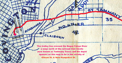
In Covington, the trolley depot appeared to be near the intersection of Kirkland and North New Hampshire St. It entered into Covington along East Clark Street, merged with what is now North Claiborne, and then merged into Kirkland Street.
The trolley car at the Abita Springs depot
The trolley ended up bankrupt in 1918. Efforts to save it, and even extend a separate line of Madisonville, did not succeed.
Steamer Margaret To Connect With Trolley
Motor Car Trolley Changes Schedule
To purchase a booklet with the complete story of the Mandeville to Covington Trolley Car, click on the link below:
See also: