
In 1917 real estate sales in the new southern section of Abita Springs began picking up. Here is a map that showed New Orleans residents where south Abita Springs was located, in relation to Mandeville, Slidell, and Covington. There were two train tracks that served the community. One track was the main railroad from Slidell, and the other was the motor car trolley from Covington to a boat dock on the Mandeville lakefront.
Click on the image to make it larger and more readable.
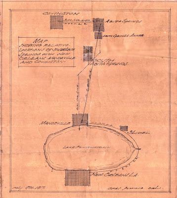
A 1917 showing the location of south Abita Springs
There were no bridges across the Rigolets at this time, and Slidell was a small but growing city with several large industries, having been chartered in 1888.
See also:
Brief History of Abita Springs
Abita Springs Music History
Abita Springs Development Proposal 1887
The Doodlebug Trolley Motor Car