
Recently we looked at a 1904 map showing the area of downtown Covington below Gibson Street between New Hampshire St. and Florida Street.
Today we move northward and look at the same map showing what is above Gibson street. A lot was going on in 1904 north of Gibson street, and here it is.
Click on the images to make them larger.

In the above image, we see Gibson street at the very bottom, with New Hampshire crossing it on the left. Running down Gibson Street were the train tracks that brought people into Covington over the Bogue Falaya river.

In front of what is now Hebert's Cleaners, the tracks split into two, with one track curving northward and the remaining track continuing westward. The track heading northward served the freight/cargo loading platform, seen below.

That remaining track on Gibson St. immediately split into two tracks again, this time with the upper track serving the passenger loading platform at the train depot on the northeast corner of the Gibson/New Hampshire Street intersection.

To the west of the intersection, where the Maritime Pilots Institute is today, there was a large warehouse with a train unloading platform of its own.
Heading eastward on Gibson, towards the right, we come across the Commercial Hotel, which later became the Patrick Hotel, which later became Hebert's Cleaners. The building pictured below was, unfortunately, destroyed by the 1997 tornado. It has been replaced by a one story brick structure.


The small building to the left of Commercial Hotel was a saloon in 1904 and is now Brooks Bike Shop.

On the other side of the Commercial Hotel was the large W.R. Badon Livery, an L shaped building that fronted both on Columbia Street and Gibson Street. So the present day Rock N Blues Cafe was at one time a livery stable.

Continuing along Gibson towards Columbia Street, we pass a small building, then cross Columbia and find another Saloon, located where today there is the Dependable Glass parking lot.
We turn north on Columbia and find adjacent to the saloon a barber shop. We go past the alleyway and find on the west side of Columbia St. a Chinese laundry, then a "lodge" room, and finally, at the corner of Lockwood,a general store. Everything else east of the intersection is residential dwellings, except a grocery store at the intersection of Lockwood and Florida Streets.
If we head west, to the left, we come across Uncle "Bobs" Livery stables. Then we get to the intersection of Lockwood and New Hampshire, where we come across a huge general store, with a warehouse adjacent, and its own train track spur and cargo loading platform. This was the future site of Burns Furniture Store.

Across the intersection we see another small warehouse next to the tracks, and coming down New Hampshire, we see the tracks split again, with one heading for where Marsolan's Feed & Seed will be located in 36 years. Those rails are still visible at the Covington Trailhead park.

The rails from long ago
A note on the map at that location says that the railroad is planning to build a 30 foot tall water tower at that location. A small scale replica of that water tower can be seen at the Covington trailhead as well.

The splitting of the tracks in this manner, forming a triangle with the base on Gibson and peak near Kirkland street, allowed the train to "turn around" and head back out Covington on the same track it entered on. The train would take the first split northward and go until its last car cleared the top split, then it would back down the trailhead's western track and ease backward onto Gibson again, this time pointing in the opposite direction.

Now back to the 1904 map, starting at the Covington Trailhead, we continue down New Hampshire Street where we come to another warehouse, another general store, and just south of that a "carriage house" where the future Deluxe Theater will be built. This is in the vicinity of where Lee Finance and Holistic Life Approach are located.

The Deluxe Theater building at the left


In the extreme lower left corner of this map section, we see a large building labelled "warehouse." That would be the future Alexius Brothers Hardware Store location, now the Once in a While Gift Shop.


The Woodwright Shop where once a general store stood
Further up New Hampshire St., where Lola Restaurant is currently located, there was a "coal pocket" alongside the tracks. Now on those tracks is a caboose that serves as a kitchen, and a couple of passenger train cars which have been converted into dining rooms for Lola.

The train tracks continued to head upward towards the area where the Justice Center is today.
Most of this section of the map is populated by residential dwellings, but there are a few commercial establishments. A large general store is located in the northwest corner of the Columbia St./Lockwood St. intersection, and another general store is located on the northeast corner of the same intersection.
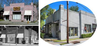
That corner, now occupied by Armbruster Art School (and the Lions Den Salon for Men), was at one time a funeral home and later the Suella Shop and later Roberts Beauty School.
Meanwhile, up in the extreme upper right corner of the map, there is a blacksmith shop on the southeast corner of the Kirkland St./Florida St. intersection, which is now a parking lot diagonally across from the cemetery.


A Walk Around Covington in 1904 - Part 1
A Walk Around Covington in 1904 - Part 2
Covington Sanborn Map 1927 - Part 3NOTE:
The buildings on these maps were color coded to indicate type of
construction and materials, so most of them are yellow, wood frame, some
of them are red, brick, and a few of them are blue, made of stone.