
Yesterday we looked at a section of a detailed map of Covington made in 1904, examining the stores and structures south of Boston Street between New Hampshire and Florida Streets that were there 118 years ago.
Today we look at the blocks north of Boston Street to Gibson Street. This view comes from a map of the buildings and businesses provided by the 1904 Sanborn maps of Covington, which are available from the Library of Congress website.
Here is the section of the map we will look at today. I have added some boldface lettering to help you read what's written on the buildings.
Click on the images to make them larger.

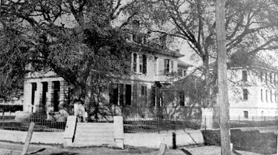
Starting at the lower left hand corner, at the intersection of Boston Street and New Hampshire Street, we see the future location of the Southern Hotel. At that time, it looks like there was a large brick structure there, with a kitchen in the rear L-shaped portion of the building.
Across the street, of course, is the old courthouse, also made out of brick, and the multi-story jail at its right rear corner.
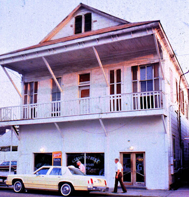
Traveling up New Hampshire St., we come to the alleyway leading into the ox lot, which, at its entrance, had a tailor shop according to the map. This is where the St. Tammany Farmer newspaper office is today. Of course, back in 1904, the offices of the St. Tammany Farmer were still at the northwest corner of Lee Lane and Boston (where the Half Moon Gift Shop used to be and the Blitch Knevel Architectural Office is today). The Farmer moved from Lee Lane to New Hampshire Street in 1916.

The St. Tammany Farmer office in 1975
For years I thought the Poole Bros. Livery and Stables were originally at this location, but I see that according to the 1904 map there was a small tailor shop there and the original Poole livery building was actually further up the street.


On the other side of New Hampshire, at the corner, we see another livery, this one being the Stroble and Warren Livery, situated at the future location of the Star Theater which was built in 1942.

The Star Theater (built on the location of a livery stable)
Coming down the east side of the street, we come across the Oyster Saloon. This location, I am told, is soon to become another restaurant, although for the past dozen or so years, it has been attorney's offices.
Moving over to the right, we come across the alleyway next to the Jail, and find an upholstery shop. Going up the alleyway to Gibson Street, we come to the alleyway entrance which has another saloon on the right, where the Mattina Bella restaurant is located today (and Nathan's Sandwich Shop years ago).

Nathan's Sandwich Shop at the location of a 1904 Saloon
To the right of the alleyway entrance (on the west) is even another saloon (a parking lot today), and on the other side of that is a barber shop.
Glancing across Gibson street at this point we see Covington's first train depot, with double railroad tracks passing by in front of it and a curved section of track passing behind it. More on that later.

Turning back eastward, to the right on the map, we go along Gibson past the saloon and see the two story Roubion Hotel, now an empty lot, but not long ago the Gibson Street lounge.
Across the street from there was the famous Commercial Hotel (which became the Patrick Hotel). Arriving at Columbia Street at the corner of Gibson, there is a grocery store on the southwest corner of that intersection. That building, originally known as the Pere Planche Grocery, is destined to become the Little Napoleon Bar.

Coming down Columbia Street at that point, we pass by offices and a vacant storefront on the west side, and look over at the east side of the street at the two story brick building then housing a bank.
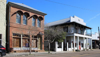
The bank building on Columbia Street built of red brick
From left to right: Dependable Glass, bank building, St. Tammany Art Association, and HJ Smiths Son General Merchandise Store
South of the bank on the 1904 map is a warehouse, and adjacent to that is a general store, which is the site of the present day St. Tammany Art Association (and former location of the Nichols Toy Store.) seen in the photograph below.

Next on the map, we go by the entrance to the alleyway, and find over on the west side of Columbia Street there's a large drug store. Across a vacant lot south of the drug store is a barber shop, which is next door to a Chinese laundry.
The laundry faces another general store across the street on the south side of the alley entrance, located where the new section of H. J. Smiths Sons General Merchandise is located today. This isn't where the old original H. J. Smiths Sons General Merchandise store was (and is still today), that building, marked "General Store," is seen between the two meat markets on the map.


This is interesting. Not only a meat market directly across the street, but two more meat markets located on the east side of Columbia, sandwiched in-between three (or is it four) general stores? HJ Smiths Sons was surrounded by meat markets at that time.
From the middle general store on the east side of the street, we look across Columbia St. and see another grocery, then south of that is a saloon, and south of that and adjacent is another grocery. Tucked in the corner of that grocery (in the northwest corner of Boston and Columbia Streets) is a harness shop. (See the arrow.)
So here we are, back on Boston Street, and heading to the right, eastward, we come to another saloon, in a building shaped like this one pictured below.

On the corner, there's a vacant lot on the 1904 map where the carpet store is now.
Turning the corner at Florida Street, we head upward (northward), past the alleyway, on up to Gibson St. , where we turn left (westward) on Gibson and see a Boarding House. There were certainly no shortages of boarding houses and hotels on the street where the trains arrived regularly hauling passengers from New Orleans for the weekend and/or the summer.
In the middle of this block was a large warehouse, which I believe is still the location of a large building that is a warehouse for H. J. Smith Sons General Merchandise store.

That ends the tour of these two blocks in 1904, but the Sanborn maps always had a few inset maps showing building complexes that were outside the main map area. Here is the inset map in 1904 for Dixon Academy and St. Scholastica Convent.


NOTE: The buildings on these maps were color coded to indicate type of construction and materials, so most of them are yellow, wood frame, some of them are red, brick, and a few of them are blue, made of stone.
A Walk Around Covington in 1904, Part One